Open Source Urban Housing for the Caribbean using Roman inspired design

The Roman empire in its peak glory had figured out a few things that modernity is still catching up on. Monuments such as the colliseum still stand because of special concrete that we only just now re-discovered how to make. They had also figured out a number of important important urban housing principles we seem to have forgotten. This project seeks to learn from the their wisdom, particularly around the Roman Domus and its free air conditioning.
Volunteer opportunity: This in-process architecture collaboration by engineer Andrew Malone extends the open source housing design toolkit from the Open Building Institute (an Open Source effort to make ecological and affordable housing widely available), to create eco-compatibile ancient Roman inspired designs to enhance urban housing comfort and safety in lower income hurricane prone carribean countries, such as Hati, Cuba, Puerto Rico and the Dominican Republic, as well as to consider and apply the principles of urban design for new developments.
Architect Statement
My wife and extended family are from the Dominican Republic and I noticed that many warm climate areas could be using ancient traditional approaches to urban housing to make it much more comfortable, secure and sustainable. I seek to address some the following common shortcomings
- Low quality construction in Caribbean urban landscapes
- Lack of sustainable and culturally relevant building designs
- Need for hurricane resistant, water contamination resistant and socially defensible residences
- Preservation/re-introduction of local heritage through architectural and urban design
Project or Program Description
- Project Objective: Complete the architectural design, structural engineering, mechanical engineering, equipment selection & specification, and hard cost estimate required to construct an affordable, environmentally sustainable urban mixed-use prototype villa that can be unitized as an urban fabric building for warm climate communities. Particularly focused on the Caribbean Islands.
- Methods and Approach:
- Research and analysis of the Roman Domus and its adaptation to Caribbean climate and culture
- Design and development of a prototype building design that integrates Roman and Caribbean architectural elements
- Evaluation and assessment of the prototype's cost/energy performance and community impact
- Collaboration with a structural engineer and architect to incorporate low cost open source plan set that can be legally built in the Spanish Caribbean
- Selection of a suitable site in a Caribbean city for the prototype construction (Ref: Old San Juan and Culebra Island)
- Deliverables
- Research and Analysis Summary
- Structural Engineering & Architecture plan and specification set
- Contributing files to add to the Open Building Institute toolkit library: https://www.openbuildinginstitute.org/library
- Creation of a digital model using Open Source design software: https://www.sweethome3d.com
- Future plan for live energy and environmental assessment of a constructed prototype's electrical & water usage performance as well as actual carbon cost of construction
Appendices
Research for the project is based initially on the corpus of documents referenced in the appendix.
- The Roman Domus as a Caribbean Urban Housing Solution - Andy Malone
- The Original Green - Steve Mouzon
- Smart Dwelling - Steve Mouzon
- A Living Tradition - Steve Mouzon
- Architecture For The Poor - Hassan Fathy
- Mass Wall Masonry, Vaulted Floors and Stairs Structural Engineering - John Ochsendorf, Matthew DeJong & Philippe Block
- How to Build a Small Town - Wrath of Gnon
- Using Models of Historic Towns as Templates by @WrathofGnon
- Duplication Through Replication - Leon Kreir
- A Town Well Planned
Appendix A
The Roman Domus as a Caribbean Urban Housing Solution
Blog Post by Andrew Malone, Wednesday, August 3, 2016
https://andrewmalone.blogspot.com/2016/08/the-roman-domus-as-caribbean-urban.html
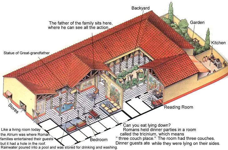
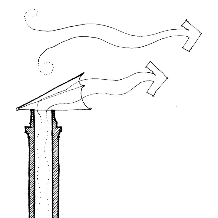
I've been on a bit of a kick right now learning about the Roman Domus; an ancient urban housing solution from about 2000 years ago. It all started with a simple question. Why do they have a pool of water (impluvium) in the center of the living room (atrium) like that?
Well, it turns out that the impluvium is a much more functional feature than I realized. It's actually a remarkable rainwater collection, storage and home cooling device all in one. If you're looking for the best sustainability solutions, and I think we all should be, it makes a lot of sense to look to the past. To a time when fossil fuels were still locked in their original state and people had to make every day human life work without them. Once we've scoured the past for amazing resource saving ideas, then by all means fire up your gas oven or take a flight halfway around the world. Let's use our resources to their highest and best purpose.
In this post I’ll address timeless issues, like rainwater collection, greywater systems, passive cooling, sustainable finance, and suggest some modern layout improvements to the domus for use in our lives today.
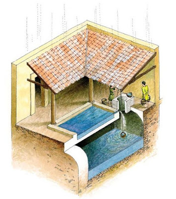
In short, ancient Romans collected rainwater from their roofs, filtered it through a sand filter and stored it in a subterranean cistern for later use in home cooling and cleaning. All for free. Let’s look at how we might reap some of the same benefits from clever design today. According to this handy Reddit thread:
Households usually collected their own rainwater from the roof to supplement aqueduct supply. The first rains would be allowed to run off the roof into a basin (impluvium) in the atrium of the house, and out through a drain into the street. Once the rain had washed the roof clean, the drain to the street was stopped-up, and another hole in the impluvium basin was opened to allow clean rainwater to fill the cistern. Usually the cistern mouth had a sediment trap on it as well, so that only clean rainwater would get into the holding tank.
Like so:
Followed by Wikipedia’s description:
Inspection (without excavation) of impluvia in Paestum, Pompeii and Rome indicated that the pavement surface in the impluvia was porous, or that the non-porous stone tiles were separated by gaps significant enough to allow a substantial quantity of water caught in the basin of the impluvium to filter through the cracks and, beyond, through layers of gravel and sand into a holding chamber below ground. The circular stone opening (visible in the photograph, resembling a chimney pot) allows easy access by bucket and rope to this private, filtered and naturally cooled water supply. In wet seasons, excess water that could not pass through the filter would overflow the basin and exit the building, and any sediment or debris remaining in the surface basin could be swept away.
In hot weather, water can be drawn from the cistern chamber (or sourced from municipal supplies outside the domus) and cast into the shallow pool to evaporate and provide a cooling effect to the entire atrium. As the water evaporates, the surrounding air is cooled and becomes heavier and flows into the living spaces and is replaced by air drawn through the hole in the ceiling above (compluvium). The combination of the compluvium and impluvium formed an ingenious, effective and attractive manner of collecting, filtering and cooling rainwater and making it available for household use as well as providing cooling of the living spaces. (emphasis added)
In modern times, the manual labor used to draw water from the cistern would be replaced by pumps and the water itself could be sent to toilets and irrigation or could be treated and used to supplement or replace the city system (which is usually not 100% potable anyway).
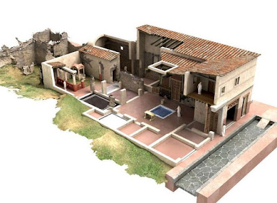
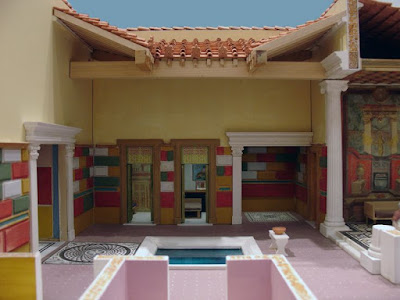
Here are a couple more images of the atrium, compluvium and impluvium set up. The walls of the house are made of rubble mass wall masonry covered with painted plaster and sometimes stone or tile. The floor is also a stone or mosaic floor. The roof supported by wooden beams set into masonry pockets is slanted inward and features a ceramic tile roofing system with gutters and drain spouts from the four corners of the compluvium to direct rainwater into the center of the impluvium.

Since the atrium is exposed to seasonal weather changes, this system doesn’t make sense in temperate zone climates, but is ideally suited to tropical and sub-tropical zones. Looking at the typical climate in Pompeii where some of the best examples can be found I discovered that original Roman Mediterranean climate would have been slightly cooler, but not unlike the Deep South and Caribbean.
My wife is Dominican and we spend a fair amount of time in Santo Domingo, the oldest colonial city in the Americas. The Zona Colonial has a lot of really wonderful architecture,

and some of it even follows a loosely similar concept with interior courtyards and pools
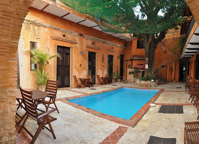
Historic Landmark Hotel Doña Elvira
But the average house built over the last 50-70 years looks a lot like the examples below.
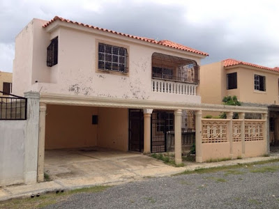

In most of the Caribbean it is quite common to live the entire year without air conditioning. Since it’s an island, the cost of electricity is high and once you become accustomed to the heat it’s bearable but not always comfortable. The rain is frequent, but usually pleasant and warm. Also water service is occasionally interrupted and the tap water is not always potable. It is wise to boil or filter city water before consumption. As local water systems age and the equipment to treat your own water drops in price, this may increasingly become the norm. In Santo Domingo burglary is (increasingly less of) an issue so most families put bars on their windows and balconies to keep out intruders.
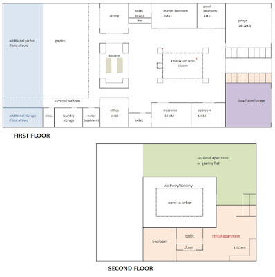
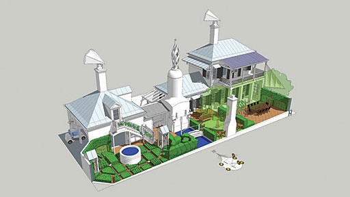
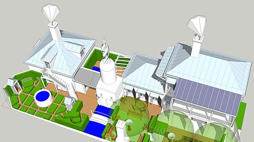
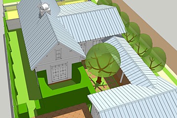
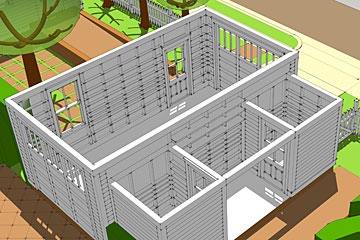
Let’s take a look at the total floor plan for a typical domus.

You’ll notice the Roman domus has a few other advantages. The whole house is inwardly focused and places windows and potential 2nd floor balconies on the inside away from possible burglars. Also, because the streets would have been filled with people and animals, they were noisy and polluted. The Romans built their homes with street facing retail only reserving a single entrance door for themselves. These retail spaces helped to pay for the costs of the house and served the public interest. Today, it is easy to imagine creating a second floor above the retail spaces for live-work units that pay for the main house.
The central room (#5 tablinium) served as the meeting place for the house. It was the focal point and divided the public space in the atrium from the private space in the garden-court (#14 peristylium).
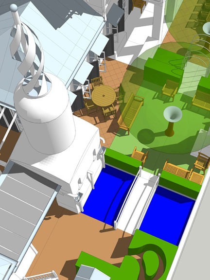
As a possible solution to urban housing in the Caribbean the Roman Domus would provide an excellent solution. In the Dominican Republic, they reserve their front yard primarily for the automobile anyway. It would be simple to re-purpose the two commercial spaces in the Roman design for a street facing garage that could eventually be converted to retail space in the event that the family needs the income or prefers to use taxis and transit. The need for security is similar to the Roman situation and providing bars on the roof over the compluvium and at the perimeter of the peristylium is an option.
Below, I’ve re-imagined the uses in a modern floor plan. Doing away with the traditional office-like tablinium and replacing that with an open kitchen. The meeting place of our modern lives. The kitchen I envision would have two mobile workstations on castors (shown in grey) that could be configured as service and prep islands or as casual dining and conversational surfaces. A second floor could be easily added for additional living space or to rent to the shopkeepers as supplementary income. The impluvium with cistern would remain and the collected rainwater could be used as grey-water to power toilets and irrigation or could be treated in a water treatment closet and used throughout the house. Adding electrical battery storage first and solar power cells second would enable the house to operate almost entirely off grid and would avoid any disruptions in service common on the islands. The garden could be edible or just a simple yet elegant backyard surrounded by covered walkway. As a typical fabric building, these homes meet most of the tests diagrammed in Steve Mouzon's exceptional work on the Smart Dwelling.
It is typical in the region to build the home structure with poured concrete columns/beams, the walls constructed of concrete block and plaster, and clay tile roofs. That is actually very similar to the traditional Roman construction and the added mass makes sense to help keep the house cool and durable. Even the heaviest rains can simply be wiped off the stone or ceramic flooring and masonry walls.
In a country with high energy costs and a favorable climate this system could make the interior of modern homes much more comfortable and solve several other major issues with typical Caribbean urban architecture.
Appendix B
The Original Green
Book by Steve Mouzon, 2010
Synopsis from the companion website: https://originalgreen.org/
Originally, before the Thermostat Age, the places we built and buildings we built had no choice but to be green, otherwise people would freeze to death in the winter, die of heat strokes by summer, starve to death, or other really bad things would happen to them. Today, as we are working to re-learn how to live sustainably, much of the focus is on the gadgetry of green: Gizmo Green. This notion that we can simply invent more efficient mechanisms, and throw in some bamboo to boot, is only a small part of real sustainability.
So this is what the Original Green makes... sustainable buildings in sustainable places... but what is it, really? The Original Green is the collective intelligence behind those places. In common terms, it’s the sustainability all our great-grandparents knew by heart.
The operating system of the Original Green is something called a Living Tradition; it spreads the wisdom of sustainability in ways vaguely similar to how nature spreads genetic material. Living Traditions bear about as much resemblance to an historical tradition as a living creature does to a fossil. One is alive, while the other is not. With that having been said, preservation is the act of ongoing sustainability, because how can we live sustainably if we keep throwing places and buildings away?
The best living traditions are held by the public at large, rather than just a few people. And if a living tradition is to produce sustainability, it must involve everyone. Our behavior must improve, or our machines can’t save us. In short, there’s something for everyone to do. And while Gizmo Green solutions are hurt by economic downturns, Original Green measures fare much better, because most of them operate naturally.
Appendix C
Smart Dwelling I & II
Blog Series by Steve Mouzon, 2009
Table of Contents
- WSJ SmartDwelling
- The Tower of Wind & Water
- Breeze Chimneys
- Sideyard Sail
- Laundry Eave
- Green Walls
- Kitchen Garden
- Windows & shutters
- Invisible Things
- SmartDwelling II
The Wall Street Journal on SmartDwelling I
https://originalgreen.org/blog/2009/the-wall-street-journal-on.html
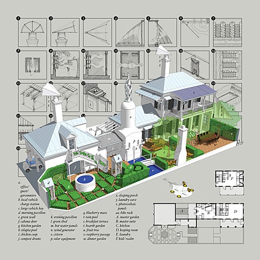
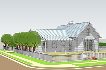
Monday, the Wall Street Journal ran a story on The Green House of the Future, which featured designs by four architects: William McDonough, Rios Clemente Hale, Cook + Fox, and myself. My design, SmartDwelling I, is pictured above... the previous post and several of the next ones will focus on aspects of the house that contribute to its sustainability.
The Journal article created a lot of buzz this week... Twitter had too many tweets to count, and the blogosphere was loaded with references, too. Green Building Advisor was one of the first to pick up the story, as was Treehugger. Jetson Green has a poll where you can vote for your favorite of the four designs... scroll down to the bottom of their article to vote. Fast Company commented on the designs, as did New West, which appreciated the focus on smaller designs. I don’t know about the other designs, but SmartDwelling I has only 1,200 square feet of conditioned space, and yet houses three beds and two baths. Its interior contains numerous space-saving innovations which I’ll cover in another post.
The New Regionalist was very emphatic on his preference among the four designs. PlaceShakers and NewsMakers devoted their entire post on the 27th to SmartDwelling I, and the Mother Nature Network singled out SmartDwelling I for praise. The Washington Post reacted negatively to the Journal article, pointing out that our first priority must be to reshape our neighborhoods. Too bad they didn’t realize that SmartDwelling I was specifically designed for an urban lot (40’ x 100’) that is served by a rear lane or alley. In short, it works in many infill conditions, or in creating new New Urbanist neighborhoods. The Huffington Post indicated that it was one of their most-read and most-commented-upon green stories this week. Planetizen, Businessweek, CNU New England, ArchNewsNow, and a number of others also picked up the story.
Here are some SmartDwelling I ideas that didn’t make it into the Wall Street Journal article, but which you might find useful: My design is consistent with the objectives of the New Urban Guild's Project:SmartDwelling, which will produce highly sustainable homes for the major regions of the US. Regional issues are crucial to sustainability: climate, regionally available materials and skill sets, occasional regional atmospheric (hurricanes, etc.) and geologic (earthquakes, etc.) events, and culture. Because this is the first house designed explicitly on the SmartDwelling Project principles, I'm calling it SmartDwelling I; it is designed for the Gulf Coast region. I founded the Guild nearly a decade ago; today, it consists of 65 New Urbanist architects and designers.
SmartDwelling I includes a number of inventions, such as the double-cranking windows & shutters to channel breezes, the Breeze Chimneys and Sideyard Sail (based on the nautical heritage of the Gulf Coast,) the Green Shed, the Cool Dip, the Laundry Eave, the Curtain Columns, and a number of interior innovations. But the primary design criteria wasn't "Is it new?" but rather "Can it work?" This means that some things need to be invented to solve today's problems. Our ancestors never had to worry about generating electricity, for example. Other things, such as the shape of the roof, have been demonstrated for centuries to be the most durable. So this home is neither historical nor futuristic; rather, it is pragmatic, because it is based on things that work best in the long run.
WSJ on SmartDwelling I - The Tower of Wind & Water
https://originalgreen.org/blog/2009/wsj-on-smartdwelling-i--.html
This morning, the Wall Street Journal ran a story on The Green House of the Future, which featured designs by four architects: William McDonough, Rios Clemente Hale, Cook + Fox, and myself. My design, SmartDwelling I, is pictured above... the next several blog posts will focus on aspects of the house that contribute to its sustainability.
The Tower of Wind & Water is the central feature in the top image. Here’s a closer view. Rainwater is collected around the entire house in gutters, then runs to either side of the tower where it burbles into conductor heads that channel it into the Rain Pool, celebrating the arrival of new rainwater with sight and sound. The Rain Pool is the boundary between the Hearth Garden from the Kitchen Garden.
Rainwater is then pulled up as needed out of the Rain Pool to the cistern, which is the round part of the tower. Elevating the cistern allows water to gravity-flow from there to anywhere on the main level, where it can be used for irrigation or other greywater uses.
The top element of the Tower of Wind & Water is a wind generator that produces electricity. Nobody makes this exact shape of wind generator yet... many of the current generation of generators look as if they were engineered but not designed, leaving them inherently unlovable. This one, on the other hand, does its best to be beautiful while it is generating your electricity. The ground level of the Tower of Wind & Water contains all of the alternative energy equipment for the house.
Breeze Chimneys
https://originalgreen.org/blog/2011/smartdwelling-i---breeze.html

There's much more to SmartDwelling I than the things I wrote about two years ago when it was published in the Wall Street Journal's Green House of the Future story. Really cool stuff is afoot with Project:SmartDwelling, so this will be the first of several new posts looking at SmartDwelling elements.
SmartDwelling I with the two breeze chimneys at the top
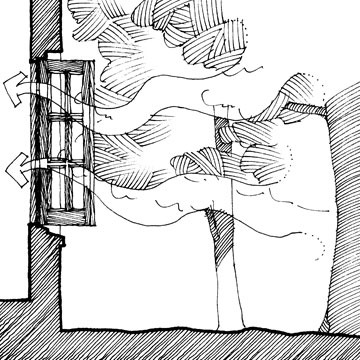
top view of Breeze Chimney
There are two Breeze Chimneys on SmartDwelling I, which was designed for the US Gulf Coast region. Because it's a land by the sea, I decided to use seafaring materials for the Breeze Chimneys. As we'll see in a moment, Breeze Chimneys in other parts of the country could be made out of other materials like sheet metal. The framework is built of small spars, like those which frame sails on sailboats. The spars could either be made of wood or fiberglass. The shroud is sail cloth stretched over the spars. This assembly is attached to a ring at the top of the chimney that rotates freely. Here's how it works:
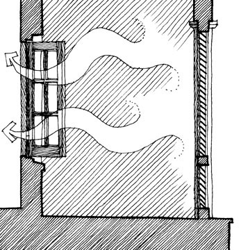
section through Breeze Chimney showing air flow
The Breeze Chimney is designed to turn into the wind, like a weathervane. The open end of the Breeze Chimney is always leeward as a result. There's a phenomenon in physics known as the Venturi Effect, and it works like this: air moving past an opening tends to pull gases or liquids out of the opening. If you're old enough to remember cars before fuel injection, then it was the Venturi Effect that made the carburetors work.
Breeze chimneys behave the same way. They have another thing working for them as well: the Thermal Chimney Effect. Because hot air rises when given the opportunity, hot air in a tube like a chimney flue will rise out of the tube, pulling other air in behind it from the room below. To start a breeze chimney, all you need to do is to open a window somewhere in the house.
Pulling in air almost as warm as the air exhausted by the Breeze Chimney wouldn't do much good, so you need to find a window around the house or shop where the air is coolest.
The best place would be under a grove of trees or big shrubs. Not only do the leaves shade the area around the window, but they also cool the air even further by giving off water vapor. It can easily be 10-15 degrees cooler under a shady grove or in a thicket.
A louvered verandah like the ones found throughout the Bahamas would be good because the louvers prevent the sun from getting into the porch and warming it up. A porch on the shady side of the house would work equally well.
A breeze chimney works best in late afternoon or early evening, when the air has cooled a bit from the heat of the day. Porches on the eastern side of the building would be coolest at this time of day. There's no reason you have to use the same window, however… you could experiment to see what works best for you. But in any case, it's the act of opening the window that starts the Breeze Chimney's operation because without replacement air pulling into the house, the Breeze Chimney can't pull air out. So think of it as an attic fan that doesn't require any electricity.

side view of breeze chimney
What about storms? Wouldn't the sail cloth tear in high winds, flooding the house? Clearly, there needs to be some way of shutting the Breeze Chimney in a storm, or when you're going to be away from home for awhile. See the heavy black line on the right side of this drawing? It's meant to represent a spring metal arc that holds the spars up. There would be two cords coming down the chimney. Pull one of the cords, and that pulls the spring metal arc over to the left, collapsing the shroud. Pull the other one, and it pops back up. I haven't yet built a Breeze Chimney, so I'm sure it would require a bit of tinkering, but that's the general idea of how it should work.
The house above was designed for a competition we never expected to win. It was intended as a critique of the Gizmo Green competition program and, just as I expected, the jurors didn't view it very kindly. I'll blog more about it later… my point of showing it here is to illustrate how differently Breeze Chimneys can be designed.
This house was designed for Dallas. A century ago, you could find pivoting sheet metal roof vents all over the Midwest and Southwest. So I designed this Breeze Chimney to be built of the same material. There are only two differences between this Breeze Chimney and the old pivoting roof vents. First, it's a good bit larger than the old ones so it can ventilate the whole house. Second, the old pivoting roof vents usually vented the attic. In this design, there's a chimney (concealed by the roof) that connects the cap to the living spaces below.
SmartDwelling I - Sideyard Sail
https://originalgreen.org/blog/2009/smartdwelling-i---sideyard.html

SmartDwelling I, published recently by the Wall Street Journal in their Green House of the Future article has a number of innovations that aren’t so much inventions as they are re-purposing things we’ve known about for a very long time. Green Walls are one such pattern; the Laundry Eave is another.
SmartDwelling I was designed for the Gulf Coast, where there is a nautical heritage, as the early towns and cities were all built with a direct dependence on commerce across the Gulf. So when I started looking for a way to catch breezes coming down the street and redirect a portion of the breeze through the sideyard, a sail was an obvious choice.
The Sideyard Sail can be furled in a storm, of course, in order to protect the sail cloth... and also to avoid sending high storm winds through your side yard. It works by pivoting a boom out over the frontage garden. If there is no frontage garden, then the front garden wall should be made tall enough (this one is) so that the boom is above head height. But that’s OK... that simply assures a private side garden.
Incidentally, the original Sideyard Sail was envisioned for Schooner Bay, a wonderful new town in the Bahamas, on the eastern shore of Abaco. It will be a working fishing village. It has organic farms on its western border, so that you can look out over the fields and over the waters from which much of your food comes. Because of this, Schooner Bay will be one of the first new Nourishable Places to be built in recent times. Schooner Bay will also build upon all other foundations of the Original Green, making it one of the first Original Green places to be built in our time.
The first Original Green place to be designed was Sky, located in the Florida panhandle. It is now in the development approvals process, and should be under construction shortly. Sky is a veritable laboratory of Original Green ideas, breaking new ground in too many ways to count. See the Sky Method (it’s a big file; give it a few to download) for a highly organic and sequential land development method invented for Sky. It promises to bypass the normal development brain damage of millions of dollars of infrastructure investment up front before you can sell a single lot... brain damage that is actually almost impossible since the Meltdown, because banks have basically quit loaning money for new development.
SmartDwelling I - Laundry Eave
https://originalgreen.org/blog/2009/smartdwelling-i---laundry.html
SmartDwelling I, published recently by the Wall Street Journal in their Green House of the Future article has a number of innovations that aren’t so much inventions as they are re-purposing things we’ve known about for a very long time. Green Walls are one such pattern; the Laundry Eave is another.
If you don’t want to pay to electric-dry your clothes, then there are currently two common choices. The European method is to hang them on pulley-driven clothes lines over the street. Neighbors therefore know if it’s boxers or briefs, and that seems like a little too much information.
The American method is to put up a couple posts with frames on top in the back yard, and string the clotheslines between them. Problem is, as any kid knows who has spent any reasonable amount of time playing in such a back yard, running into such a clothesline while going for a fly ball or a pass can nearly take your head off, because they’ll catch you under your chin, holding your head in place while the rest of your body goes flying underneath. This is such a common phenomenon that it spawned a term in American football: “Getting clotheslined” means getting tackled by a defender who holds his arm out at neck level, just like the clothesline... leaving you to crash bone-jarringly flat of your back a moment later.
The Laundry Eave solves both of these problems. It uses the pulley, like in Europe, so that you can hang clothes out of any window on any floor of the building. But it is placed on the back or side of the building so your undies aren’t hanging out over the street.
The last element is a very deep bracketed eave that hangs over the entire clothesline, so that a shower that comes up while the clothes are drying don’t soak them all over again.
Why might you want to air-dry rather than electric-dry your clothes? The energy savings are obvious. And if you’re brave enough to commit to doing it all the time, then you don’t even need to buy a dryer. That also saves on electrical costs... at the very least, you don’t need the circuit, the wire, and the outlet. But because a clothes dryer is a big electrical load, eliminating the dryer just might make the difference in being able to go down to a smaller service. One other thing on electrical service... if you make your own electricity with photovoltaic panels, then eliminating the dryer may save a really nice chunk of change by requiring fewer photovoltaic panels. And finally, three more reasons that everyone can enjoy... air-dried clothes usually smell fresher than electric-dried ones, they’re not full of static electricity, and the clothes actually last longer!
SmartDwelling I - Green Walls
<https://originalgreen.org/blog/2009/smartdwelling-i---green.html>
SmartDwelling I, published recently by the Wall Street Journal in their Green House of the Future article has a number of innovations that aren’t so much inventions as they are re-purposing things we’ve known about for a very long time. Green Walls are one such pattern. The idea is really simple: take all building or garden walls within easy harvesting reach (say, up to 8’ tall) and plant them. The Green Walls to the left in the image above are planted against a masonry garden wall, while the Green Wall to the right is planted against the garage. And no, all those green boxes aren’t finely-clipped hedges... that’s just the closest I could get with Sketchup. This is a normal raised-bed vegetable garden.
How do you plant a Green Wall? Well, we eat fruits and a few vegetables that grow on perennial plants like fruit trees, while most vegetables grow annually: you plant them in the spring and they die in the frosts of the fall. Because annuals like fruit trees grow for many years, they can typically grow taller than annuals like onions or rhubarb. Many vegetables will never make it to the top of the wall, so the top should be reserved for perennials.
There’s an ancient art known as espaliering where fruit trees are trained tight against a wall. They never get anywhere near as large as they would growing in the wild, but they produce an amazing amount of fruit for such a tiny footprint. The tops of Green Walls are composed primarily of espaliered fruit trees.
See the lighter green below the espaliered fruit arches? That area is reserved for vegetables. Vining ones (such as beans and peas) work best. It’s not shown here because it would be largely hidden, but the area below the arch has a lattice built of pruned branches (gotta recycle, you know?) attached to the wall. Vegetables growing in this area would vine up the lattice.
Some vining vegetables don’t work so well... until now... because their fruit is so heavy. Several types of melons fit this description. No problem... SmartDwelling I envisions Melon Cradles which would be hung from the lattice when fruit sets on in the springtime, carrying their weight as they grow.
There’s a lot more to Green Walls, some of which you can read here. As you will see, they actually weren’t my idea, but rather, Julie Sanford’s. And the principles, of course, have gone back thousands of years... we’re just applying them in a certain way. You’ll also note that I was calling them Wall Gardens at the time... might even go back to that term. What do you think? Wall Gardens? Green Walls? Which is a more descriptive and more enticing term?
SmartDwelling I - The Kitchen Garden
https://originalgreen.org/blog/2009/smartdwelling-i---the-kitch.html
The Kitchen Garden is the one part of SmartDwelling I that a few people look at and say “you can’t be serious!” For them, buying food at the grocery store is simply too ingrained in their version of modern life to ever consider raising any appreciable portion of their own food. And make no mistake about it... the areas devoted to food in SmartDwelling I would likely provide most, if not all, of the food needed by a family of three or four for an entire year, assuming you used the space efficiently.
How is this possible? Doesn’t the American agricultural system require an acre or two of land (depending on where you are and how long the growing season is) to provide food for just one person? And haven’t we always known that the American agricultural system is the most efficient on earth?
Here’s the problem. America’s industrial food system is the most efficient on earth, so long as you’re measuring the man-hour efficiency of the guys on the tractors. One person on a mega-tractor as tall as a two-story house can probably work a thousand acres or more in a single day. Meanwhile, one person growing food in bio-intensive fashion has a hard time tending more than a single acre. But that guy on the mega-tractor is only a tiny part of the supply chain. Getting food to market requires truck drivers to take it to the processing plant, workers in those processing plants that break it down into its food-chain parts (high fructose corn syrup, etc.) more truck drivers to take it to assembly plants where more workers turn it into soda, Chicken McNuggets or whatever, more truck drivers to take it to the distributors who hire even more truck drivers to take it to the grocery stores. Is this starting to sound like more oil than food? It is. According to Michael Pollan, delivering a single calorie of highly-processed food (most of the stuff America eats) requires 70 to 90 calories of gasoline! And this doesn’t even take into account all the people working for the processors and the people working for the food manufacturers... who also must, by the way, buy even more gas to get to work in their corporate office parks. So the efficiency of the guy on the tractor (which can cost a million dollars or more, and must be manufactured by lots of employees at John Deere, etc.) is completely an illusion.
The bio-intensive farmer, on the other hand, while tending only an acre, can take their produce to a nearby farmers’ market or sell it to local restaurants, reducing the food chain to just one person in a truck. And the food chain, rather than stretching across national boundaries, can be as short as 20-30 miles or less.
So while the man-hour efficiency of the industrial food chain is a complete illusion, the acre efficiency of bio-intensive gardening is completely real. Remember that one person working hard to tend one acre? Well, they’re not just feeding one person (or less) on that one acre like the industrial food system would do. Rather, depending on growing season and local conditions, that one acre can easily feed twenty people or more... and that’s without going to some of the extremes (like Green Walls and Melon Cradles) that SmartDwelling I includes. That’s real efficiency... one person feeding twenty people or more... and with only a tiny fraction of the appetite for gasoline that we find in the entire industrial food chain.
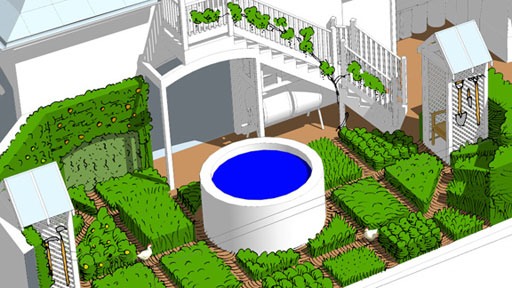
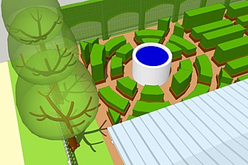
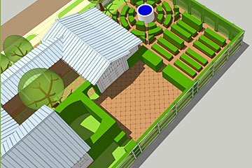
So beyond the fact that it’s highly acre-efficient, what’s so cool about the Kitchen Garden in SmartDwelling I? Lots of things. See the pool in the center? That’s a Tilapia Pool. Tilapia thrive in incredibly tight quarters... there can be more tilapia than water in a pool and they’ll do just fine. So you can think of it as a water feature, or as a big protein machine... take your pick. You’ll also notice a few chickens running around. Those are the hens that inhabit the henhouse under the stairs to the apartment/guest room/kids’ room/office/studio/workshop/whatever over the garage. You only need a few hens to eat garden pests, provide a continuous supply of fertilizer... and also a continuous supply of eggs for even more protein.
You’ve probably noticed that the vegetables grow in raised beds. Rather than single rows of plants 2-3 feet apart like industrial tractor farming requires for most crops, raised beds grow vegetables much more compactly. They’re limited only by the reach of the person tending the beds... a three-foot bed allows you to easily work the middle of the bed from any edge without bending over much, if at all.
You likely also noticed the Green Walls all around the garden. Actually, this drawing hides the near Green Wall so you can see the entire garden. but in any case, the entire garden is surrounded with Green Walls, which are highly efficient for reasons I blogged about earlier.
But this isn’t just a place to work. See the two little structures with tools handing on the lattice walls, and seats inside? The one on the right is the Morning Pavilion. That’s where you go and sit and watch the mist rising off the garden in the early mornings, maybe with a cup of coffee... and with the morning sun streaming in over your shoulder. The one on the left is the Evening Pavilion. You can sit there at the end of a day of gardening, admiring your hard-won handiwork, with the evening sun streaming in over your shoulder again, just as it did in the mists of morning.
SmartDwelling I - Windows & Shutters
<https://originalgreen.org/blog/2009/smartdwelling-i---windows-.html>
SmartDwelling I has the distinction of being the only one of the four houses published recently by the Wall Street Journal in their Green House of the Future article that could be built today. Or at least 98% of what was shown can currently be built. One of the few exceptions are the windows and shutters. That might be about to change.
Casement windows are easier to make airtight than double-hung windows because the sash squeezes the weatherstripping tight to the frame when the window closes instead of sliding along the surface of the weatherstripping like double-hung sashes must do. But casements have a problem: If you’re in a region like the Gulf Coast (for which SmartDwelling I was designed) which is frequented by hurricanes, then you really need to be able to close solid shutters over your windows to protect them from the storm. But how do you close the shutters once the window is closed? Southern European casements solve this problem by opening the casements inward rather than outward, but inward-opening casements almost always leak in a blowing rainstorm. This might be tolerable in the milder climate of southern Europe, but not on the Gulf Coast. Until now, the only choice was to close the shutters from outside the house... perched on a ladder for most windows. That’s why shuttered casements are almost non-existent there.
Until now, that is. One of the major epiphanies of SmartDwelling I occurred when I asked myself “if you can crank the casement sashes open and closed, why not crank the shutters, too?” Presto... we now have the superior weathertightness of a casement with the protection of a shutter that can be operated from indoors. But that’s not all. Notice how a casement on a crank can be opened to any position you like and left there? Well, now you can do the same thing with a shutter. As a result, you can aim the sash & shutter at the prevailing breezes, channeling air into the room. And if you open them slightly wider, where they don’t exactly line up like the ones shown above, then it literally creates a funnel shape to transform a small breath of air into a more noticeable breeze.
“That’s great,” you might say, “but why are you telling me this if I can’t buy windows like that today?” Because now we’re talking to a window manufacturer that’s strongly considering making them! I won’t reveal who it is until they’re committed to the project, but I’m really excited that this could happen quickly. As a result of this encouraging turn of events, I’m working to get the remainder of the futuristic components of SmartDwelling I on the assembly line, too. More later…
Invisible Things
https://originalgreen.org/blog/2009/smartdwelling-i---the-invis.html
Several elements of SmartDwelling I, published recently in the Wall Street Journal’s Green House of the Future article, are highly visible. Two of the more important ones, however, can”t be seen at all... at least from the ground. See the grey roof just to the left of the Tower of Wind & Water? Those are the hot water solar collectors that provide hot water to the entire house. See the blue roof covering the two-story porch? Those are photovoltaic collectors that provide electricity to SmartDwelling I.
Both sets of collectors are on low-slope roofs, so there’s no way you can see them unless you’re a long way from the house. They also occupy the entire roof... in essence, they are the roof. This means that even if you’re far enough back from the house to see the roof surface, you’re still unlikely to notice anything different.
I tried this approach first on a design for a Green Shed at Southlands, a DPZ project near Vancouver. Southlands is a place where all of the people living there will be able to get all the food they need from food grown on the property.
Contrast this with normal collectors which are usually designed for the perfect angle of maximum solar efficiency, no matter how hideous that makes them look on the roof. This attitude of getting the engineering exactly right with not a thought for design likely contributed to the demise of the first green revolution that began in the late 1960s and died in the early 1980s. Read this post to find out why.
SmartDwelling II
https://www.mouzon.com/blog/smartdwelling-ii.html
Wanda and I designed SmartDwelling II for a competition recently that we never expected to win. The competition was sponsored by two very respectable organizations which will remain nameless, but the program really disturbed us. It purported to call for a home in a hot climate (north Texas) that was both highly affordable and sustainable, but it was classic Gizmo Green, focusing solely on better equipment and materials, and inexplicably banning several passive measures. For example, it required 8' ceilings throughout although tall ceilings are essential in the deep South because they let the heat rise away from you in the afternoon.
I was disgusted with the program and didn't want to participate, but Wanda kept pushing, saying "why don't you use our entry as an opportunity to show what they should have been looking for?" So we decided to do the competition as a critique of the program in order to call attention to this completely backwards but very common approach to sustainability.
The two biggest "game-changers" that affect many other sustainability measures are things we call "Conditioning People First" and "Smaller & Smarter." Here's how Wanda and I accomplished these things in SmartDwelling II:
Conditioning People First
I blogged a few years ago on the Original Green Blog about an idea I call Living in Season. Briefly, the idea is that if you entice people outside, they get more acclimated to the local environment, needing less heating or cooling when they return indoors. I've proven this personally since moving to South Beach nearly 9 years ago, and there are other benefits, as you'll see if you scroll down in this post.
• dog run at left side doubles as driveway if there's no side street • Master Garden is surrounded by high hedges • Inner Court is shaded by a fruit tree
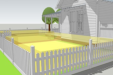
We did several things in SmartDwelling II to entice both the occupants and the neighbors outside. First, we designed the entire site as either outdoor rooms or passages… there's no standard lawn anywhere on the site (the lawn outside the fence is public property.)
Each outdoor room and passage has distinct uses. The Inner Court just off the Keeping Room is the outdoor living room. The Master Garden is a small, very private outdoor room just off the master suite where the parents can have a bit of time to themselves.
• fruit trees line left side of Kitchen garden • Green Fence at rear has espaliered fruit above vining veggies • raised beds in center radiate out from Tilapia Tank
The Outer Court (just visible above at the left end of the garage) is completely paved for shooting hoops and other activities requiring a solid surface. The Kitchen Garden at the rear of the site can replace a substantial amount of grocery budget with home-grown nourishment, helping make the neighborhood a Nourishable Place.
The edible landscape isn't confined to the Kitchen Garden, however. The Green Fence is similar in concept to the Green Wall in SmartDwelling I, and it runs all along the rear and right side of the lot has fruit trees espaliered on the top half and beans, peas, and other vegetables trained up below.
Edibles continue all around the house as well. The setbacks required by the city are narrow, and are often wasted because what can you do in a 5' strip of land except let the dogs run? Here, however, we use them as a linear orchard, with fruit trees all down the left side of the house. Oh, and that's the West side, so they also shade the house from the scorching Texas afternoon sun. The front yard is a bit of a flight of fancy. People rhapsodize about "amber waves of grain," so why not have a wheat lawn as shown here? If the residents would rather have vegetables, then we're beginning to learn how to grow them beautifully, so the neighbors won't mind.
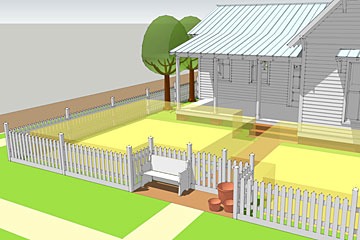
We're not just trying to entice the residents outdoors, but the neighbors as well. If every home on a block gave some sort of Gift to the Street, then the street becomes a place more people want to walk. Anything we can do to enhance a neighborhood's walkability builds its overall sustainability as well. In this case, the Gift to the Street is built into a fence recess at the front gate. It houses a bench on one side, for a place to rest, and potted flowers to the right, for a bit of visual delight.
Smaller & Smarter
view of garage & Green Shed with roof removed shows how much
storage space can be recovered in stud walls
SmartDwelling II is only 1,043 square feet, substantially smaller than the 1,400 square foot program. It houses three bedrooms and two baths within this envelope by doing a number of innovative things. Clothes are stored in armoires rather than closets, saving roughly 4" per wall. It doesn't sound like much, but it really adds up. We carved into interior walls throughout the house, using the wall cavities as storage instead of wasting them. We used a dining booth rather than a dining room, saving a lot of square footage by seating people in a cozier setting. Go to a restaurant anywhere, and you can see how decisively people choose booths over open tables when given the choice.
Other Frugal Things
Building a smaller footprint starts many virtuous cycles. For example, smaller floor plans are much easier to cross-ventilate because they are small enough that you can give every room windows on at least two different walls, enhancing air flow. And light from two sides isn't just more beautiful, it helps to daylight the room so that you likely don't need to cut on the lights until evening. But we incorporated a number of other natural features as well:
The program required a front-facing garage, but we ignored this requirement for several reasons, chiefly because of the fact that buildings in temperate regions should be as long as possible East to West, reducing the length of the Western wall and increasing the Southern wall, where it's easier to admit the low winter sun while shading out the high summer sun. But a front-facing garage would force the house to be long North-to-South, dramatically lengthening the Western wall to the Texas sun. Front-facing garages also reduce the walkability of the street for several reasons, including the fact that houses with garage doors as major street features are notoriously less lovable. Because this house sat on a corner lot, we entered the garage from the side street. And as noted in a caption above, if this design is used in the middle of the block, a driveway can run down the right side to the Outer Court, which then doubles as a motor court.
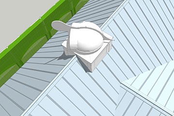
The roofing is a major passive cooling device. Mill-finish 5V Crimp metal roofing was the predominant roofing material for many years in the South because it bounces roughly 90% of the sun's heat back up to the sky before it even gets into the building envelope. We've designed this vent hood similar to the Breeze Chimneys on SmartDwelling I: The fin turns the hood into the wind, so that the air flowing across it pulls warm air out of the house. It's sort of like a whole-house fan that doesn't need electricity.
There's more, of course. I'll have to do another blog post showing the interior innovations that haven't been mentioned here… there's some really cool stuff. But what about the competition? We were right: SmartDwelling II never stood a chance. The prime sponsoring organization apparently took offense at the number of program requirements we ignored, but I'm still happy Wanda talked me into doing it, because more of us have to start calling out the Gizmo Green for what it really is: a strategy that cannot deliver real sustainability on its own.
~Steve Mouzon, Jan 28, 2012, 1:00 PM
Appendix D
A Living Tradition
Book by Steve Mouzon, 2018
Synopsis from Book Description
A Living Tradition [Architecture of the Bahamas] is a richly illustrated description of the architectural traditions of the Bahamas over the past four centuries. But this is not just another catalog of architecture in paradise. Rather, it is a workbook, or "pattern book," that examines each pattern of architecture in detail, such as the proportion of a window, the slope of a roof, or the design of a garden wall. By doing so, it directs the design of new buildings that can become part of the centuries-long tradition of the architecture of the Most-Loved Places of the Bahamas. Until now, pattern books of our day were something akin to recipe books, instructing which details to use for each style of architecture. A Living Tradition re-thinks pattern books from the ground up. It is principle-based, not style-based. Those principles are based on the architecture that makes the most sense for the Bahamas, not a random collection of historical styles. And each principle is explained in the plain-spoken fashion of "we do this because..." One reason for building this way was to be sustainable. Originally (before the Thermostat Age,) traditional architecture had no choice but to be green, otherwise people would suffer or even die from weather and storm conditions. A Living Tradition explains the Original Green of each pattern that contributes to sustainability, re-infusing architecture with the green wisdom all our ancestors knew by heart. With this book, it's not just about style anymore. This second edition has robust new first and last chapters dealing with urbanism, and detailing the reasons why town-building is more resilient and more sustainable than resort-building. The Original Green is expanded with the four foundations of sustainable societies within sustainable places because even if the physical artifacts of a place are highly sustainable, the society could nonetheless fail within it if it doesn't keep these foundations strong.
Appendix E
Architecture for the Poor
Book by Hassan Fathy, 1968
Synopsis from Book Description
Architecture for the Poor describes Hassan Fathy's plan for building the village of New Gourna, near Luxor, Egypt, without the use of more modern and expensive materials such as steel and concrete. Using mud bricks, the native technique that Fathy learned in Nubia, and such traditional Egyptian architectural designs as enclosed courtyards and vaulted roofing, Fathy worked with the villagers to tailor his designs to their needs. He taught them how to work with the bricks, supervised the erection of the buildings, and encouraged the revival of such ancient crafts as claustra (lattice designs in the mudwork) to adorn the buildings.
Appendix F
Guastavino Vaulting: The Art of Structural Tile
Book by John Ochsendorf, 2013
Synopsis from Book Description
The first monograph to celebrate the architectural legacy of the Guastavino family is now available in paperback. First-generation Spanish immigrants Rafael Guastavino and his son Rafael Jr. oversaw the construction of thousands of spectacular tile vaults across the United States between the 1880s and the 1950s. These versatile, strong, and fireproof vaults were built by Guastavino in more than two hundred major buildings in Manhattan and in hundreds more across the country, including Grand Central Terminal, Carnegie Hall, the Biltmore Estate, the Cathedral of St. John the Divine, the Registry Room at Ellis Island, and many major university buildings. Guastavino Vaulting blends a scholarly history of the technology with archival images, drawings, and stunning photographs that illustrate the variety and endurance of this building method.
Appendix G
How to Build a Small Town
How to Build a Small Town in Texas
Part I: The Place.

JUL 06, 2021
Of all the questions I get on Twitter the most common is this: “How do you build a town?” We know well how it used to be done, but these last one or two centuries we have forgotten how to do it (with only a handful of notable exceptions during the last century1). The other day I was asked again, but this time with a set of premises that made the question a little easier to approach. I have anonymized all the details but the general idea remains: four guys (friends) with money have bought a suitably large piece of land in Texas and now want to create a car-free human-scaled town2 of the kind that I am always writing about.
In this text I intend to set out the most bare-bone basic premises for how to start a good town, what is needed to build something anti-fragile3 and sustainable4 under the above mentioned scenario. I will go back to this text and edit it, add points, or discuss certain aspects deeper in future texts, especially those points that stimulate questions or controversy.
This is my first published long form. It is my general idea to write as little as possible while still getting the point across. I might delete this first attempt.
- Size and borders: “You can’t have a garden without fences.”
To create a human scaled town we first establish what is a good size, and this is simply one third of a square kilometer, or 82 acres, or 0.13 square miles. 80 acres was the upper limit for a good family farm in medieval England, and it is still the size at which the most flexible and efficient farms run, both modern and more old fashioned Amish family farms. It allows a town where no point can’t be reached on foot in 15 minutes, and it allows comfortable living for a population of 3000, which was considered the ideal size in medieval Europe: the upper limit of efficiency and comfort, productivity and harmony: more and you get crowded, less and you risk being without some important trades and activities. Even though the premise talks about a town of 600, we plan three centuries ahead for a maximum population of ca. 3000.
A good town (the urban) is clearly defined and set apart from the countryside (the rural). The suburban has no place here. Hence the town needs to be as clearly marked out and defined as the individual family lots will be: to here, but no further. For this purpose we will mark out land to be used as a wall, raised embankment, hedge, fence, moat, canal, etc. Some sort of edge which is not routinely nor distractedly crossed.
As for shape, I recommend a somewhat irregularly oval shape, near round in one extreme, or rice grain shaped in the other extreme, for the simple reason that the best towns and cities seems to be oval to some degree5. As far as possible the existing topography should be kept or even enhanced. Perfectly flat land is only popular with boring developers. So: no bulldozing allowed. Existing trees should be left and existing paths should be left in place (even when slightly inconvenient). New paths and streets should follow the contours of the land. Anything historic (an old campsite, an ancient grave or remains of an old farmstead) should be kept and protected and venerated. History is in short supply in new developments, and interesting stories can be woven around something as mundane as an abandoned old cart or well.

The oval (left) and the (Japanese) grain of rice. Good basic shapes for a town.
- Water, energy, food and connections: the needs hierarchy of towns.
Since the premise is Texas, and undeveloped land, I am imagining land that is more or less parched, but with short and intense annual rains that risk flooding the entire area. The town will be in a perpetual state of drought and need to be prepared for flash floods6. Hence cisterns, reservoirs, water harvesting will be vital, and whatever gets built, roofs will harvest water into private cisterns or ponds, and all streets will direct stormwater to overflow-proofed cisterns. An area the size of two or three football pitches outside the town will be devoted to flood protection and temporary storage of water. During most the year this land will be dry and a perfect spot for sports, barbecues, festivals, playgrounds, fairs and markets.
This arrangement should make the town self-sustainable in household water at least. Pumping groundwater should not be an option, it is simply not sustainable in an arid/semi-desert environment and Texans already know how to build and manage water harvesting infrastructure. There is no need to reinvent the wheel and spend tons of resources on piping in distant water.
There will be an urge to build each home optimized for air conditioning. Don’t. All buildings must be useful and livable even with the power cut. Hence, natural ventilation, strategically designed windows that open, etc. is necessary. Obviously you can add AC (Air conditioner) on top of that, but in no way should the town be dependent on AC. I don’t think a town can casually produce the energy it needs by itself (for that a far more serious effort would be needed), but even if the grid is cut, it should have enough to power food storage, basic lights and communications (WiFi etc.). This can be achieved with limited private and public PV (photo voltaic or solar power). For hot water, solar heaters are useful even in a Texan winter, and all homes will be equipped with fireplaces, wood stoves and chimneys.
Once you remove the need for heating, cooling and transport from a town’s energy needs, you are left with something that will easily run on limited solar (and the attached batteries) in case of a grid failure. This will also save the town and its people large amounts of money even in the near future.
For food, the town should not spare any effort to be self-sustainable. Food items are also a prime export product, especially high-end refined items (exporting raw materials/food isn’t a good use of resources). It provides jobs and income and is a sure way to draw tourists. For this purpose there will be no lawns, but plenty of gardens, orchards, street side herbs, roof top apiaries and flowers to feed the bees that inhabit them. The rural area (the “market garden zone”) surrounding the town out to a radius of one mile should be devoted more or less entirely to food production in some form, and it should be farmed primarily by the people living in town on a professional or hobby level (either one is fine: create the best allotment system in Texas!). The second belt, is the farm zone. Here I would recommend, if not enough farmers could be found, to offer the land at good prices to Amish families to farm. 800 acres is enough for 10 farms. They also have the expertise to run a farm in any sort of energy crises. The rule of thumb is that only people who live directly off the land should live in the rural area (the “farm zone”).
Inside the town basic facilities for food processing should be found. From feed and dairy refinement to meat processing. People should be encouraged to plant espaliered fruit trees on every suitable south facing wall. Poultry, pigs and rabbits should be kept, not only for meat, eggs, but also to produce high quality fertilizer for the poor soil in the area. And this goes for humanure7 as well. Pesticides and chemical fertilizers should be completely banned from the start. Water should be treated organically and as low-tech as possible, on site.
A good “code-hack” for any small town was developed in Seaside, Florida: “one 14x14 feet area of a lot has no height limitation”8. This will spur people to build towers and spires, which are useful for housing bats and pigeons which will help in pest control (pigeons are also an unbeatable supply of food). Some space in the town itself should be reserved for food production: dovecotes, commons for grazing, etc. A small town like this needs no parks, so instead institute seed gardens (small gardens used only for producing seeds) of vegetables and herbs. Encourage people to keep flowers (to help honey production): consider instituting a program where each square foot of flower pot space gives you a certain weight of honey from the public or private apiary.
Ideally you want to build a new town in a region where there are already people present, near larger cities or along a “necklace” of small towns. This makes it easier to attract citizens, and it also makes the town less isolated, more easily connected to outside markets, tourism etc. but in this scenario the land is marginal and a bit far from towns and airports. Hence, save space for a convenient and scenic (you can’t do fast at this scale) rail or canal or river ferry connection to the nearest larger town. It will raise the value of the town land itself and everything it produces will have a better access to a market (especially perishables). It is also a great way to bring tourism into the city without having to provide parking.
It is possible to build isolated cities but the chances of succeeding is so slim I would not recommend it. Decide from the beginning where you want a possible rail station, by the gate? Inside the town? Through the town? It is easy to prepare the ground now, rather than wait until it is all developed and built up.
- Materials and harmony.
All materials used, as far as possible, should be of local origin. In Texas that means the town will be built from rammed earth, adobe bricks, some fired bricks or stone. No concrete, vinyl sidings, clapboard (not ideal in an arid town environment anyway), plastic etc. Before anything gets built, a pattern book9 for the town must be developed that should have a few very basic buildings types for new residents to easily build and that fits in anywhere in town. A color pattern will be developed using locally accessible earth tones and pigments (if the local geology provides some odd hue of green or yellow here’s a chance to make the town stand out from the beginning). Official or public buildings should be set in a specific color to create a coherent pattern for the town. I recommend bright yellow and white trimmings for this purpose.
- The problem of undeveloped and vacant lots.
In the beginning, especially in a town planned for 3000 but only housing 100-600, there will be plenty of empty lots. These should still be managed and walled or fenced, with the understanding that they will, sooner or later, be built upon. These “gaps” can be filled with low walls and contain gardens and playgrounds until they are sold or developed. Fast growing trees can be grown on empty land and used as energy or raw material.
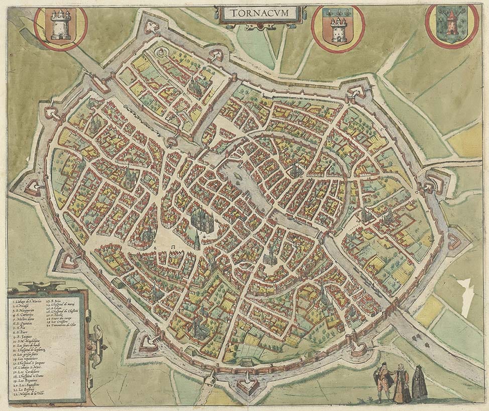
Tournai in modern Belgium. Look at all the green spaces, imagine the fresh air, the invigorating call of roosters in the morning, the scent of herbs and flowering orchards in the early summer breeze!
- Who will live there?
Obviously the town will need to generate a working income, so lots will be sold to the highest bidder, but you will also want to reserve lots for the people who matter to the town itself. I.e., you need things like a parish house, a dentist (save an excellent spot in the town center to offer at low cost to whomever decides to practice dentistry there), a schoolmaster, a clinic, a grocery store (at least) etc. Your first and most obvious potential clientele will be the builders, plasterers, masons, well drillers, cistern makers, ditch diggers, hod carriers, carpenters, plumbers, glaziers, electricians, wifi technicians, who are actually building the town, so you will want to offer them a chance to live there, affordable, within their means. Let the people who contribute and have skin in the game have a first go at acquiring land. The surveyor who surveys his own home will work twice as accurately, the carpenter who builds for himself will work twice as hard.
You also want craftsmen and small business owners to relocate to the town and they will need workers. All buildings must be owner occupied. You do not want a town of renters or absent landlords. Set lots aside to develop “guest houses”, inns, small hotels or rentable properties for short or long-term visitors and guests. Reserve the most valuable street front lots to people who want to run stores, eateries and other businesses.
Without motor vehicles and endless power flowing through the socket, this will be a remarkably quiet town. The loudest noise you will hear on a typical day will be children playing or a conversation between neighbors in the street. And so it should be.
- Build to the edge of the lot
Keep the lots small, and all buildings aligned right to the edge of the lot facing the street, leaving backyards and courtyards, common or private, and walled gardens on unused space.
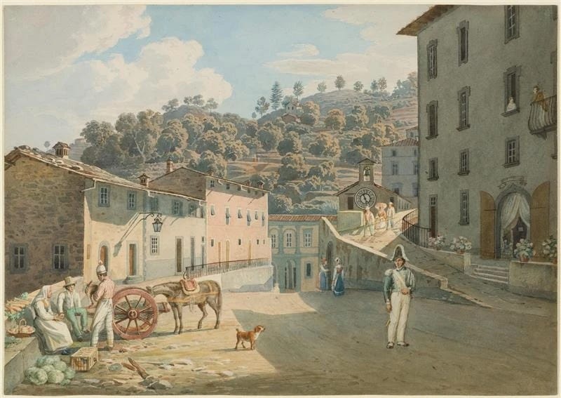
All buildings in this water color of an Italian town are built to the edge of the lot and we can only see the front elevation (and one of the sides of the building on the far left). This saves us money because we only need to consider the decoration of one side, or maybe two, in the case of smaller humbler town houses. If we want to add to the house later, it is easy to add more rooms on the back, taking some space from the often ample courtyard or backyard.
- Personality, neighborhoods, and character.
Even a small town needs neighborhoods, and neighborhoods need a character and “color” or personality of their own. Since there are four guys building this town, assign a quarter each for their personal whims and quirks. One guy might have a thing for public wall mounted fountains, so he asks all the builders there to install them. Another might have a thing for the color purple, so he asks all buildings to use the color in some way for doors or trimmings and flower pots etc. This sounds whimsical but it is vital: most people love the quirky and detest the bland.
- The Story, the founding Myth.
Any town needs a story or a founding myth, and if it does not, let’s make one up10. The easiest way to make a new development, town or building fit in is to make it look like it has always been there. The newest building on the block should look like the oldest. In the case of Texas, this means the town will be built to a Mission, Spanish-colonial, or German-colonial style (or a mixture of these). It should look like it was founded and laid down in 1667 or 1746, not 2022. People will call pastiche or Disneyland on this, but don’t listen to them: if you use genuine materials and colors it will only take a few years to mellow in and look like it has always been here.
- Build the least valuable lots first.
Don’t develop the best lots and the best locations first. Save them for later. In the meantime, “pop-up” stores and light movable homes and buildings, simple stick frames place holders, can be placed on the prime lots, to be replaced by more permanent constructions as needs and wishes becomes apparent. Here’s a chance to build the funky saloons, the charming post office, the rows and rows of shops and cafes that makes a town a fun place to visit without committing for entire generations. If they do great, make them permanent, if not, move them out, replace them, experiment.
The same thing applies for street furniture: fountains, benches, water troughs, hitching posts etc. Build fast and simple place holders, and see which ones are used and loved: make them permanent. The ones that no one cares about, remove or change or replace. Rome wasn’t built in a day.
Also remember the golden rule of place making: when building anything, build on the least attractive part and improve it while keeping the views of the more beautiful parts intact.
- Public space.
Texas is hot and sunny so streets should be relatively narrow and main streets should have covered walkways or porticoes (look at Bologna for a famous example, or old Havana with its tarpaulins shading the streets, or old Singapore with its covered merchant sidewalks). Useful street trees should of course be planted, as many as possibly under the limitations of water and rainfall, with a good mixture of flowering trees, shade trees, evergreens and fruit trees, both male and female, with an emphasis on useful native trees. Give each neighborhood its own square and make the entrances gated or arched, and the streets offset (i.e. no street intersects another). Each neighborhood or even set of homes should have a pocket square11 adjacent. The town itself should have a central square12 (even if it does not have to be in the center of the town itself: it can also be in front of one of the main gates or up on the hill or down in the hollow), with some sort of trees and water feature if possible. Water should be available in the form of fountains and faucets, water troughs and wall mounted fountains as far as possible almost everywhere.
- A grand entrance.
Just like the front door is the most important part of a home or building in how it interacts with its neighbors and the street itself, so should the town have a dignified entrance. A gate or portal or archway or flanked street or special pavement etc., something that tells the visitor “this is our town, we live here, and we are proud of it!” You really can’t go over the top here. The gate can be lockable if wished, or open at all times. It can be freestanding or built into homes or a building in itself

By the City Gate by Frederick Arthur Bridgman (1847-1928)
- How to live without cars.
The most common response when I claim we should keep cars out of cities is “what about emergency services?” Having a single ambulance in town is no problem, and hopefully it will be rare to even see it on the streets. Same with firefighters. Long hoses and mobile pumps and ladders are good enough for a town with no buildings over two or three floors. Still, a small ladder engine can be kept in town if deemed necessary.
A town without cars is more accessible for everyone, including the handicapped, wheelchairs, etc., especially for the two large groups of people who can not drive even under the best of circumstances: the elderly and the young.
There are many ways to move goods and materials, pianos and washing machines, that do not include moving vans and trucks (even though obviously exceptions can be made for these purposes), cargo bicycles, wheelbarrows, hand powered cargo rail etc. For residents who are temporarily unable to leave their homes a human-scaled walkable town is the perfect setting for quick and local delivery services, or just plain charitable spirits and “helping each other out.”
But where will people keep their cars? Outside the city boundaries somewhere.
- To grid or not to grid.
I have this pet theory that you can tell how free a city is by how irregular its street pattern is. Grids are great for managing traffic, and nothing else really. A town with an irregular street pattern is far more charming. If you think of a town as a home, the streets in a gridded town are corridors, not useful for much anything, but in a town with an irregular street pattern they become rooms, or real places. If you have a grand building, let it stop a street (in urbanism this is sometimes called a “terminating view” or a “focused street”). If you have several beautiful elevations in a row, curve the street to properly show them to the pedestrian (it can be hard to take in a building if you are next to it on a straight street or lot line). Consider also if streets are always necessary. Sometimes it can be better to divide buildings and blocks be series of interconnecting pocket squares or little plazas.
Consider what a street can be good for apart from just foot traffic. Is the street narrow enough to shelter from the sun? Can the south side be covered to provide a place for shops or outdoor seating for a cafe? Is there a convenient corner to stop and fix a flat tire or water a thirsty mule? And what about when you enter a new street, is the “scene” well set? Does every turn and every corner fulfill its potential to present a charming or attractive scene?
I hope to add to the themes in this text and also follow it up in a Part II: The People, where I will focus on how to set things up to maximize the chances that an organic, real, honest, community, forms. This Substack will be open to free subscribers for a while. I wish to thank the Substack staff that have kindly reached out to me before and after registering.
Léon Krier is responsible for most of them.
Defined here as a town that is completely accessible and useful on foot or by hand and with human or animal muscle power, both in terms of size, space use, and materials (for example anywhere in the town is reachable on foot within 10-15 minutes, and buildings are not so tall so that they can’t be used without elevators/lifts/escalators etc.).
Defined here as the way Nassim Nicholas Taleb uses the word: that which benefits from stresses and shocks.
Defined here as: “a place or practice that can keep going even after someone pulls the plug or disconnects the grid.”
In other cultures square or rectangular towns exists, as does circular, but according to the premises for this scenario let us go with something vaguely medieval and Western.
The most common cause of death in the desert is drowning (flash floods).
Humanure, i.e. human waste, nightsoil. A valuable resource. A good book on this is Holy Shit: Managing Manure to Save Mankind, by Gene Logsdon. Recommended reading.
I tweet about this here:
A book with plans and layouts and elevations of acceptable or recommended designs along with color samples and materials guidance. “Anything in the pattern book gets an automatic building permit: anything that is built and fits, gets added to the pattern book.” See historical English and U.S. pattern books for examples.
A book that tells of real world examples of “made” up founding stories is Charleston Fancy: Little Houses and Big Dreams in the Holy City, by Witold Rybczynski. Recommended reading.
A pocket square may or may not be a made up word or jargon. Nevertheless, here it is defined as a square that is roughly of the same size, or smaller, as the building lots that surround it. A proper square is usually larger than the surrounding buildings (i.e. it serves more than two buildings). Stockholm’s Gamla Stan is a good example of a town with nice pocket squares.
A good guide to the proper dimensions of a square or a public plaza is given in The Art of Building Cities: City Building According to Its Artistic Fundamentals, by Camillo Sitte. However, there hasn’t been a decent public square built since the 16th century, so please be prepared to sit down and really work on this part of the city. If you can get it right you will have created something not seen since the Renaissance.
Appendix H
On Copying Old Designs
@WrathofGnon
https://twitter.com/wrathofgnon/status/1148825660963426309?t=Ifv9p9V7sJb6d_X8e_gCYQ&s=19
“Thanks to Louis XIV we have a very good idea of how European cities looked in the 17th-19th centuries. About 260 models of cities and fortifications were built up until 1870. 100 of them have survived. We can start copying the best of these if we want to build sustainable cities."
Note: Leavenworth, WA became a destination by doing this in miniature


Appendix I
Duplication Through Replication - Leon Kreir
https://www.strongtowns.org/journal/2019/5/27/do-you-want-to-know-what-works
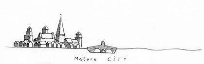
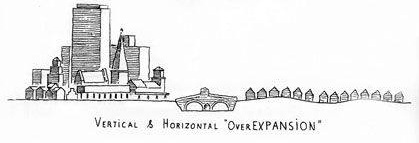
After infill, a mature city has two options for growth. Expansion or duplication. He provides two sketches to illustrate the point; the first of a technically-administered city that has become obsessed with growth. Krier calls this “Vertical & horizontal overexpansion”—the vertical and horizontal simplification of the city to constituents of a growth model.
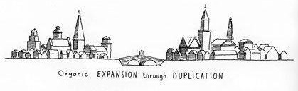
The other Krier sketch he calls “Organic expansion through duplication,” and he even throws in the word “organic,” which I would correlate to “complex.”
Appendix J
A Town Well Planned
Blog Series by Alexander Dukes, 2017
https://www.strongtowns.org/journal/2017/3/13/a-town-well-planned
This article is part of a series in which Strong Towns member and contributor Alexander Dukes proposes a “Civic Development System” for designing strong neighborhoods. The system's regulations are split into three core mechanisms — Master Street Plans, Land Use Zoning, and Form Plans — and intended to provide maximum flexibility for developers in a way that fosters economically successful communities. We hope Alexander's ideas serve as valuable inspiration when thinking about design options for your own neighborhood.
Read previous articles in this series:
- Introduction to a Town Well Planned
- Determining Public Will
- Parcels and Master Street Plans
- Street Design
- Hierarchical Zoning
- Zoning with Context
In this new series of articles, I hope to propose a three-part regulatory system for managing municipal design. While this initial explanation of the system may seem heavy handed, I encourage the reader to stick with the series. I believe this much simplified means of civic planning is more accessible and comprehensible for the average citizen, and will ultimately lead to better results for the public.

Photo from United State Mission Geneva
I. WHO PLANS?
The public has a fundamental right to define the nature of their urban environment. In the past, the nature of the urban environment was often defined by a king, lord, or general who obtained custody of the town or fortress and fashioned plans according to their own design. Today, we live in democracies whose governments are “of the people, by the people, for the people.” Thus, in the spirit of common law precedent, the nature of the urban environment must now be defined by the people. Don’t let any developer tell you otherwise.
The urban environment is and always has been, planned. To build any improved structure —from the most humble tepee to the Empire State Building— requires some level of foresight in the acts of designing and constructing the shelter. Towns and cities are composed of hundreds or thousands of buildings; therefore, towns and cities require planning no less robust than architects provide for a client’s building. Just as a building requires thorough, detailed architectural plans to affect good construction, so does a municipality need good plans to affect good development.
In most American towns and cities, the public has entrusted the design of the urban environment to civic planners organized into planning departments. The public acts as the “client” in this relationship while the planning department acts as the architect. To that purpose, planning departments design cities and towns through a system of plans and codes that regulate three key features of land development:
- The Arrangement of land - the design of the parcel, block, and street network applied to the land
- The Use of land - the purpose for which land is exploited (i.e. residential, office, industrial, etc.)
- The Form of land - the broad design of land improvements (i.e. detached/attached structures, etc.)
A thorough, detailed plan for municipal development will regulate all three of these features in a way that expresses the public consensus for how the town or city should develop. A vague plan will neglect one or two of these features, affording private interests the liberty to build outside of the public consensus.
II. THE INADEQUACY OF LAND USE ZONING
Today, planning departments design municipalities primarily through zoning code regulations. Zoning codes dictate how land is used by creating districts or “zones,” such as: residential, agricultural, office, commercial, or industrial. On the surface, this is good. Planners should broadly regulate land use to prevent conflicting land uses from harming one another. The problem is that land use zoning is often the only regulatory tool in most planners’ toolbox.
Take a look at an example of a typical zoning code:
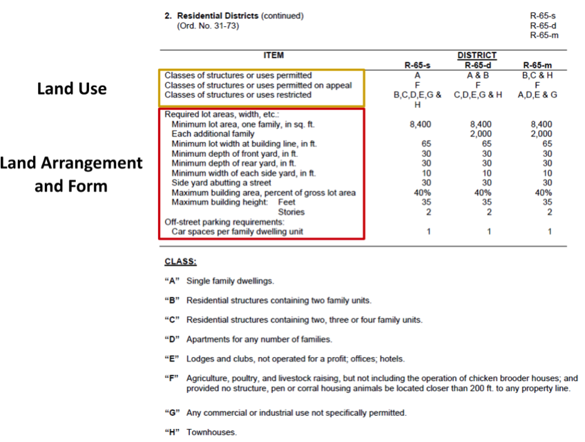
In the code excerpt above, we see that the municipality is attempting to define the Arrangement, Use, and Form of residential land through a zoning district that is primarily concerned with Use.
Aggregating the three features of municipal land development into a zoning code severely limits planners’ ability to respond to the innumerable scenarios that they will encounter in the course of their duties. While there are a number of different districts to choose from (twenty for the residential land use alone in this municipality’s code), the Arrangement and Form land development features are applied out of context because the code is intended to regulate land use. This tendency to aggregate “arrangement” and “form” into the land “use” feature is part of the reason why most projects in municipalities must seek variances. For example, 80 percent of development projects in Ithaca, NY recently had to seek variances from its zoning code. As Better Towns and Cities writes:
Approximately 80 percent of building projects in the City of Ithaca go to the Board of Zoning Appeals [for variances from the zoning code], it was reported to Form Ithaca. That indicates the system needs fixing. The great majority of these requests are granted--but not before significant time and money is spent. ‘Uncertainty has a cost,’ says Ithaca developer Frost Travis. ‘You can’t get financing until you know if you are going to be able to do 28 or 36 units, and that could make the difference in whether you get loan approval at all. I'm intrigued by the idea of taking a 1,000-page code into a much shorter, visual, user-friendly document.’
So not only does regulating land development through a land use zoning code neglect the features of arrangement and form, it adds unnecessary cost and uncertainty to projects.
To realize the urban environment that the public desires, planning departments need regulatory tools that manage each feature of land development independently. A municipality should have one regulatory tool for the arrangement of land, another for the use of land, and a third governing the form of improvements on the land. These independent regulatory tools will allow each land development feature to be properly managed within its own discrete context. In the remainder of this article I will describe my vision for the nature of each of these tools.
III. TRIPARTITE LAND DEVELOPMENT REGULATION
1. Objective: Regulate the Arrangement of Municipal Land
Tool: Master Street Plans
The first and most important feature of land development is the arrangement of land into streets, and blocks. In the past, streets and blocks were realized through a master street plan. All of those beautifully rendered designs for cities like Washington DC, Savannah, and the Commissioners’ 1811 Plan for New York City are essentially master street plans. These plans promoted walking by using small blocks and frequent street intersections to shorten the distance between amenities. Subdividing the blocks into parcels typically permitted an intense mix of merchants and residences that democratized land development in the municipality.
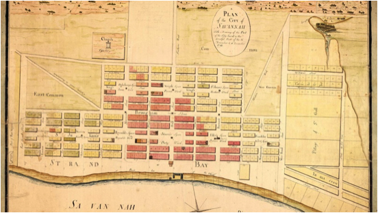
Savannah, Georgia: “Oglethorpe Plan”
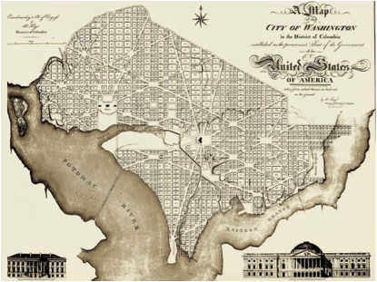
Washington, DC: “L’Enfant Plan”
Today, we have subdivision regulations, which are a mere textual description of some minimums and maximums developers should not exceed when developing land. A textual regulation like these can never achieve the geographic context of a purpose-designed plan. Further, many of the limits described are incompatible with a walkable environment. There are regulations out there with minimum block lengths of 600 feet and maximums of 1,800 feet. Most publications concerned with walkability suggest that block lengths should have a maximum of 600 feet.
All of these elements combine to make subdivision regulations an inadequate tool for arranging land. Because the blocks produced by subdivision regulations are so large, automobiles are a necessity to access the amenities on each block. This is why it is typical for these large blocks to host only one land use at a time rather than the mix of uses smaller, walkable blocks can support.
A town or city’s streets are its “bones.” Without good bones a municipality cannot hope to realize a public vision for its development. Planning departments should adopt master street plans so they can return the design of streets and blocks back to the public.
2. Objective: Regulate the Use of Developed Land
Tool: Basic Land Use Zoning
Land use zoning can still be a useful tool for affecting good land development. Without the baggage of the “arrangement” and “form” features, the zoning code has the ability to become much more simplistic and therefore more useful. Instead of having a “jack of all trades” (and master of none) zoning code containing twenty or more land use districts, municipalities can make due with ten or less.
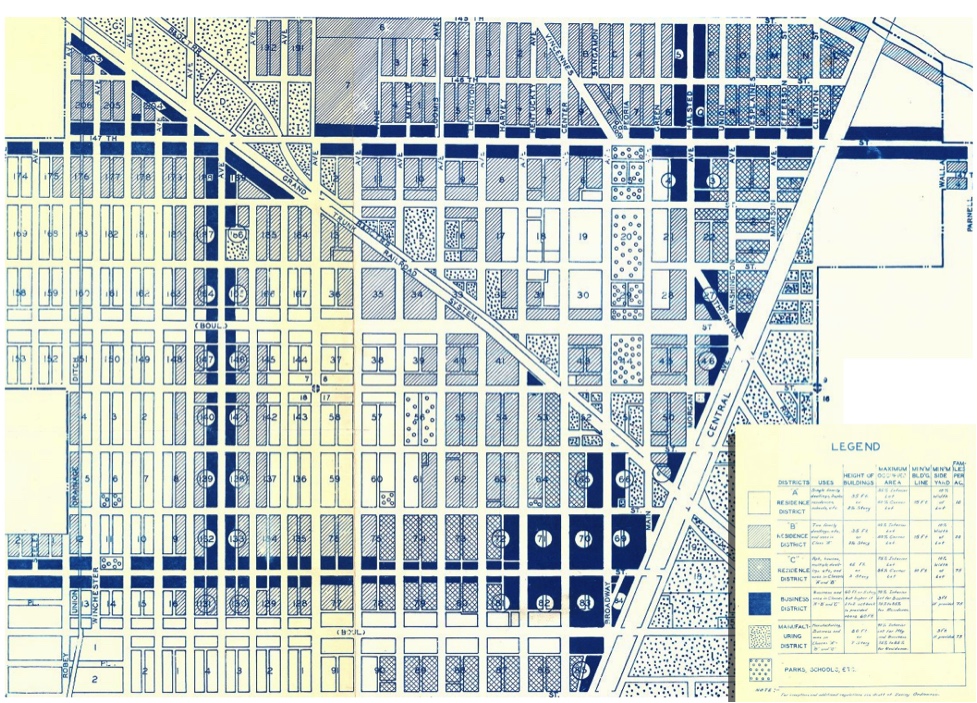
Harvey, IL Zoning Plan c. 1930, prepared by the city engineer (cropped and modified by Alexander Dukes to fit page). Original image source: The University of Chicago
As originally conceived, zoning was to be used in conjunction with a master street plan. This allowed zoning to operate in a very detailed, tight-knit way that was highly contextual to a municipality’s geography (see image above). Combined with a master street plan and a form plan, civic planners can manage land use with the nuance and attention to detail that the public often desires.
3. Objective: Regulate the Form of Developed Land
Tool: Form Plan and Form Based Codes
Form-based regulations like form plans and form-based codes are relatively new planning tools that regulate the broad design of improvements upon the land. A form plan is designed on top of a master street plan, and regulates each block according to its geographic context. Each block receives its own form settings for building mass, entrances, height, setback, and etcetera. A great example of a form plan is pictured below:

Carmel, Indiana Midtown Regulating Plan. Prepared by Speck and Associates. (Cropped and modified by Alexander Dukes to fit page)
To avoid clutter, more general form regulations that affect all buildings in an area should be handled outside of the form plan. These general form regulations should instead be included in a form based code. Appropriate regulations for a form code are: façade materials, roof design (flat or pitched), windows, porches, balconies, whether or not the building is attached to its neighbor, and etcetera. Used together, the form plan and form code are the final tools the civic planner needs in their toolbox to work toward the urban environment the public desires.
IV. CONCLUSION
A regulatory system that discretely addresses each core feature of land development is vastly superior to aggregating planning controls into a zoning code. By defining precisely what is and is not permitted within communities, municipalities can begin to fully realize the urban environments their public's desire.
Undoubtedly, there will be many that are wary of granting “the government” so much power to define the nature of the urban environment. I would respond by stating that there is nothing within this tripartite system that constitutes new authority for municipalities. Today, municipal governments regulate the arrangement of streets and blocks, the use of land, and building form. They simply fail to regulate any of those features effectively.
Seaside, FL is the pinnacle of “New Urbanist” planned communities. Seaside features development regulations with strict form codes, light land use codes, and was platted according to a master street plan. Seaside did not collapse under this “burdensome” regulation. Quite to the contrary, homebuilders and commercial real estate have flocked to the area, and copycat communities have been constructed as a result.

Plan of Seaside, FL c.1980 by Duany & Plater-Zyberg

Seaside, FL c.2010
In forthcoming articles for this series, I hope to explain in greater detail how ordinary citizens and government administrators can use a tripartite land regulation system to work better together toward the goal of a town well planned.
A Town Well Planned: Determining Public Will

Source: Johnny Sanphillippo
My previous article in the “A Town Well Planned” series declared that “the public has a fundamental right to determine the nature of their urban environment.” As the public are the owners of the urban environment, the design of cities and towns should reflect “the public will.” The public will is the composite expression of the needs, values, and desires of individual citizens within a given jurisdiction.
When a mother complains that cars drive too fast for kids to ride their bikes on the street, she is expressing part of the public will. When a commuter complains that traffic moves too slowly on that same street, he is also expressing part of the public will. When residents decry the lack of affordable housing in the neighborhood around the street, they too express part of the public will. All of these expressions combine to make up the public will “mosaic” for any given town or city.
Civic planners are responsible for transforming the public’s mosaic of public will into holistic plans. The public describes the mosaic, and planners design the mosaic. Everyone helps to bring the mosaic to life.
I. The Neighborhood
Attempting to design an entire municipality as though it were homogeneous is folly. If a town or city’s urban environment is greater than a mile in diameter, it needs to be planned in neighborhood sections that aren’t much greater than a mile from end to end.
This mile-wide distance limitation is applied to the neighborhood concept because walkability is a principal objective of urban design. Studies show that people are willing to walk about a half mile to any destination that interests them. Assuming a person lived in a house at the center of a neighborhood, a person would be willing to walk about a half mile before they perceived themselves to be in a new area. This “new area” for planning purposes should be considered a different neighborhood.
Source: Johnny Sanphillippo
While this justification for a mile diameter is a subjective estimation for what constitutes a neighborhood, an independent study that sought to determine the size of what Americans perceive as “neighborhoods” found similar results:
In this report, I use responses from the 2009 American Housing Survey (AHS) as well as geographic information system (GIS) maps and tools to conclude that the distance from the typical American’s house to the edge of his or her community is between 520 and 1060 meters.
A mile is 1,609 meters long. Again, assuming a house in the center of a neighborhood, a half mile from the house would be 804.5 meters. This is nearly in the middle of Donaldson’s range of what Americans consider to be a community.
Of course, if your municipality is so large that it has more than 20 neighborhoods, it would probably be wise to consolidate some of them into “neighborhood groups” to facilitate outreach.
Finally, it is important that the boundaries of each neighborhood be drawn in vigorous consultation with the public. Though a good planner may think he or she has an idea of what boundaries constitute neighborhoods, it is likely that neighborhood residents may have some different ideas about where their spaces begin and end. Neighborhoods will be the basis for developing the mosaic of public will that is the municipal plan. It’s critical that this first step is done right.
II. Neighborhood Outreach
Once there is an acceptable public consensus on the neighborhood boundaries, civic planners should start engaging with the residents of each neighborhood in earnest. The remainder of this article will describe a few (though not all) principles that should govern planners’ outreach to neighborhoods:

Source: Johnny Sanphillippo
(1) Elect liaisons to represent the interests of each neighborhood.
Most planning departments only hold a few public meetings a year. Further, many residents have schedules that preclude them from attending public meetings. Because swaths of residents can’t attend the meetings, the public feedback planners receive is often skewed toward the few people that have the wherewithal to attend. In order to capture a more complete picture of the public will, a more effective means of neighborhood outreach is required.
To facilitate clear and concise communication between residents and the planning department, a liaison should be elected by each neighborhood. Each liaison should be responsible for holding frequent neighborhood meetings with residents. In these meetings, neighborhood residents should discuss issues amongst themselves and attempt to arrive at a consensus. Residents unable to attend the neighborhood meetings could simply write, call, or email the liaison to provide their commentary. The liaison would then report the meeting minutes and other sentiments to the planning department.
The purpose of the liaison is to compress the neighborhood’s mosaic of individual expressions into something planners can work with. This way, when the planning department does hold a public meeting, the neighborhood has a clear, concise message to communicate. Public meetings tend to be much more successful when constituents largely agree on what their own needs, values, and desires are.
Of course, in some cases the formula can and should work in reverse. If planners feel a particular neighborhood could be improved in some way, the planning department could ask the liaison to solicit ideas from residents. This would be a particularly effective way to encourage community driven tactical and lean urbanism ideas like MEMFix – a tactical urbanism initiative in Memphis, TN.
(2) Schedule public meetings between neighborhood residents, liaisons, and planning officials.
Every so often, the planning department will need to conduct public meetings with neighborhoods. If they so desire, residents should be able to schedule a meeting with the planning department through their neighborhood liaison. Depending on each neighborhood’s situation, residents may want to hold meetings with planners at different frequencies. A neighborhood that is largely left unaffected by new plans or development might only need to have an annual meeting with planning officials (if a meeting is necessary at all). Neighborhoods that will experience a significant amount of change may want to hold a public meeting four times a year.

Source: Sara Joy Proppe
(3) Conduct public meetings with a hands-on approach
When meeting with neighborhood residents, all planning department products should be presented to residents in a way they can touch and feel. PowerPoint presentations can be used to establish some context for understanding what’s being shown, but the majority of the meeting should be spent in direct interaction with both planners and the subject matter. This means that handouts, easel posters, and pinups should all be considered for use in a meeting.
Generally, handouts should be used in small meetings when 5 to 10 people can be expected to attend. Meetings expecting 11 to 50 should use easel posters so that a planner can stand beside the posters and break the crowd down into smaller groups of people. Pinups (or tape-ups if you don’t have corkboard walls available) should be used when you’re expecting more than 50 people to attend a meeting. Since a meeting with more than 50 people is likely to be held in a large space, planners can use easel posters in conjunction with the pinups.
Don’t be afraid to let residents do their own mark-ups on the handouts, posters, and pinups. In fact, planners should provide markers and pencils to assist in this natural tendency. Much can be gleaned from another pair of eyes working on a neighborhood design. Though these neighborhood meetings aren’t necessarily envisioned as charrettes, nothing’s wrong with a bit of improvisation on the spot. That’s what civic planning is all about. Often, the public will emerges right before your eyes.
(4) Subsidiarity – Make all decisions at the lowest reasonable level.
When attempting to determine the public will, it is critically important that all decisions should consider the opinion of as few or as many people who are appropriately positioned to have an opinion on the subject. Many municipal problems only need to consider the opinion of the specific neighborhood affected by proposed solutions. An example of a neighborhood level decision might be whether the neighborhood’s streets should have street trees or parallel parking. Another might be a pop-up pool party on a local block (Just, call the city first. Or maybe Philly should ease up).
However, some decisions simply should not be made at the neighborhood level. The location of a future school should not be something that is left up to the neighborhood. Rather, the school’s location should be determined by the entire municipality because the geographic distribution of schools affects everyone. A good rule of thumb for attempting to apply the principle of subsidiarity is to ask, “Would this question reasonably affect others outside of the level I am examining?”

Source: Michael Kappel
To complicate the concept further, there are some situations where the public will expressed by one constituency ought to be ignored in favor of another constituency. The Interstate Highways that plowed through vibrant neighborhoods in the past century are a perfect example of this conundrum. On one hand, suburbanites stood to gain a shorter commute from highways that ran straight into downtown urban centers. On the other hand, the neighborhoods that the highway routes ran through would surely be destroyed by the gargantuan concrete edifices.
To some extent, balancing the need for highways with the needs of neighborhoods is a question with no purely empirical answer. I imagine most people would find it hard to reasonably justify destroying neighborhoods to provide suburban residents a shorter commute…although Strong Towns' recent stories on a proposed inner-city highway in Shreveport, LA suggest otherwise.
When a highway runs through a municipality, the highway route ought to literally bend to the public will of neighborhoods. Theoretically, this would result in highways mostly being constructed along neighborhoods on the outskirts of town.
III. Conclusion
Determining the public will is hard. As previously stated, public will is often a mosaic of differing, competing interests that don’t always line up. By using neighborhoods as the fundamental planning unit and appointing a liaison to consolidate individual expressions into concise neighborhood ideas, planners can begin to have some understanding of what that mosaic looks like. By conducting regular hands-on meetings with neighborhoods, and allowing residents to paint their vision, we can begin to see those ideas in practice. Finally, planners must also be mindful of the ethical and practicality concerns that come with balancing competing public wills. If we learn to determine what the public will is, and apply ourselves in service to that public will, our municipalities can be that much closer to towns well planned.
A Town Well Planned: Parcels and Master Street Plans
The first article in the “A Town Well Planned” series proposed a three-part regulatory system for managing the design of urban environments. From here on out these articles will refer to this system as the “Civic Development System,” or “CDS” for short. The three pillars of this regulatory system are: (1) The Master Street Plan, (2) Basic Land Use Zoning Plans, and (3) Form Plans.
The next handful of articles in the “A Town Well Planned” series will use a single scenario to demonstrate how the three pillars of the Civic Development System can be leveraged to streamline and democratize municipal development. As we progress through the series, you’ll see how each of these pillars bolster and reinforce one another to provide localities and the civic planning profession with a solid framework for designing the urban environment.
This article will discuss how to arrange parcels within a Master Street Plan. Believe it or not, the best way to determine where streets should go is to determine the arrangement of parcel blocks first. That way, we can leave appropriate room for the streets and later design them to connect the space between the blocks.

I. THE SCENARIO
The theoretical scenario we will be exploring for the next few “A Town Well Planned” articles is situated on the site of the Auburn Mall, in Auburn, Alabama. For the purposes of this exercise, the Auburn Mall has closed due to its inability to attract customers to its anchor tenants—not unlike many other malls across the country. (The Auburn Mall is currently open for business, though two of its major anchors, Sears and JC Penny, have decided to close their doors.) The Auburn Mall had a gross leasable area of 527,000 square feet, and could support over 50 “stores and services.”
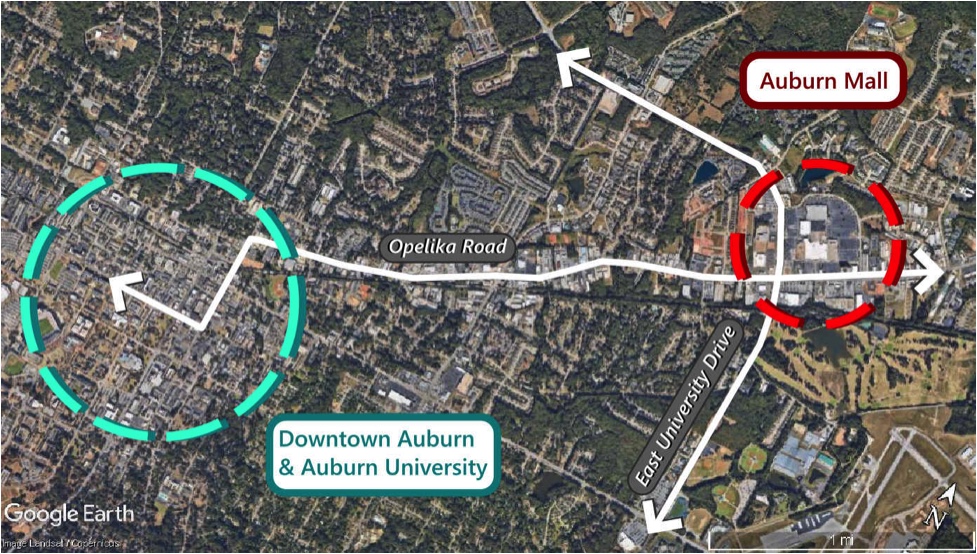
Geographically, the Auburn Mall is situated 2.7 miles from Auburn’s downtown core and Auburn University. Sited at the major intersection of East University Drive and Opelika Road, the Auburn Mall functioned as a second urban center for the city when it was constructed in 1973. Today, the site is situated a short drive from business locations for both downtown Auburn to the west and Opelika to the east. Though it would take about an hour to walk from the mall to the downtown, Auburn University offers an excellent “Tiger Transit” service to and from the mall site for students and employees. There is about a 30 minute wait time between Tiger Transit busses.
The owner of the mall parcel is looking to sell the property to developers to make a pretty penny in Auburn’s booming real estate market. However, in this scenario, redeveloping the site as a whole would financially require significant infrastructure investment from the City of Auburn. Auburn is only willing to make these investments if the platting of the new development corresponds with the city’s Civic Development System- particularly the Master Street Plan. Auburn’s Master Street Plan would require the huge mall parcel to be subdivided into a series of streets and many small parcels arranged on a grid. The city intends for these small parcels to be sold as individual lots that are affordable for middle class Auburnites looking to purchase or rent their first home or establish a small business.
After some consternation, the owner of the Auburn Mall realizes that breaking the site into many small parcels individually will allow him to make more money in the long run as opposed to selling the mall parcel in one go to a single developer. The owner accepts the platting of the Master Street Plan and subdivides his parcels accordingly. Moreover, because the mall site is undergoing a legally significant change, the new parcels that result from the subdivision must correspond with Auburn’s Basic Zoning Code and Form Plan.
II. THE PARCELS
To develop a subdivision design for the mall site, Auburn’s civic planners created a set of standardized parcels that can easily be advertised and sold to potential buyers:
Each parcel can be used as a whole, but teal and brown parcels can be subdivided at the discretion of the parcel’s final owner (after it has been sold by the mall owner). The teal colored parcels can be subdivided in two, while the brown colored parcels can be subdivided into four parts. Some permutations of the brown parcel’s subdivision will require the owner to establish a public easement through a parcel (see the dashed marks on some parcels) to prevent an alley terminating into a dead-end that traps pedestrians (this aspect will be addressed further in the Form Plan portion of the series).
The parcels designed by the planners are intentionally small, slim, and evenly divisible by one another. By having a relatively small square footage, these parcels are much more affordable than the typical suburban residential and commercial lots. By being slim, the green and purple parcels provide many more homes and businesses the opportunity to access valuable street frontage than is typical for other developments. (In fact, most apartments built today front a parking lot rather than a street.) And because the parcels are evenly divisible, the owners of brown and teal parcels can act as small scale developers, subdividing these parcels to establish small businesses like restaurants, barbershops, or micro-farms next to their homes. Brown and teal parcels can also be used whole for large apartment buildings, businesses or larger homes.
Despite their petite appearance, the four parcels types are wide enough to accommodate retail businesses, offices, apartments, and even single family detached homes- all with at least two parking spaces. Readers concerned with the size of the parcels should remember that lots of these sizes are eminently common in many downtown environments constructed prior to World War II. Some of the most beloved bars, eateries, and shops in downtown Auburn sit on lots that are even less than 25 feet wide.
Civic reserve parcels are public set-asides that the City of Auburn may use as it wishes. The city acquired these set asides in exchange for the infrastructure investments necessary to enable the development.
III. SUBDIVIDING THE SITE
Once the mall owner acquiesces to subdivide the parcel according to the Master Street Plan, the City of Auburn produces an illustrative map that depicts the arrangement of parcels that will be sold to Auburn families and entrepreneurs:
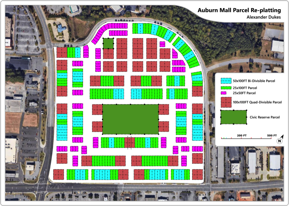
Parcels are arranged within the subdivision to be people-centered and car accommodating. Parcel blocks are spaced to both provide a wide street for parcels to front and a slimmer back alley for more utilitarian uses. These alleys are central to the city’s design. The key thing to remember here is that streets are primarily for people, while alleys are for people, cars, trash, deliveries, and any other housekeeping uses that should be generally kept off the street. This design choice clears valuable street space of nuisance uses and allows street frontage to be dedicated toward positive activities like outdoor dining, customer parking, or spontaneous recreational space. Alleys also grant more travel options for both pedestrian and automotive traffic to move through the area.
Notice that the negative space between blocks where the streets will go is not always straightly aligned. This is intentional for two reasons:
First, As Raymond Unwin conveys in his century-old classic “Town Planning in Practice,” there should be a sense of discovery within any town, and curves in the street help to evoke this sense of discovery. Curves do this by allowing the street scene to transform before your eyes as you walk through it. Essentially, curves keep things interesting.
The second reason some blocks aren’t straightly aligned is that curves help to slow cars down and provide a safer environment for pedestrians. Some spaces in the design would require curves so awkward for car traffic that they can only be used by pedestrians or cyclists. This is also intentional and will be discussed in the next article in this series where streets will be added to complete the Master Street Plan.
Finally, the subdivision design also allocates substantial space for two “civic reserve parcels.” The City of Auburn acquired these parcels in exchange for its agreement to provide the streets and infrastructure necessary for the subdivision to occur in the first place. The smaller reserve to the north will be used as a small recreational sports center, while the reserve to the south will perform double duty as both a park and drainage for the subdivision’s streets.
“When affordability meets flexibility, the result tends to be the democratization of a local real estate market.”
IV. CONCLUSION
As previously stated, the core objective of the parcels and subdivision design are to create spaces for residents that are both affordable and flexible. When affordability meets flexibility, the result tends to be the democratization of a local real estate market. In a democratized market, people naturally start experimenting to suite local tastes. In affordable and flexible spaces, large development companies with Wall Street financing tend to take a back seat to the innovation that can be found in the many hands of local entrepreneurs.
When you go to the bar in a community, the owner might be your neighbor who built the bar right next to his house after he saved up enough to start the place. Or you might pick up some local produce from the farm that another neighbor built on their rooftop. Both of these scenes are difficult to imagine in the bulk-construction, facsimile housing subdivisions we see today. The best way to achieve this community built by many hands is to offer plots of land at an affordable price, and allow the local residents and small developers living in cities to build them incrementally.
Hopefully this application of the Master Street Plan to the Auburn Mall site has demonstrated how platting small lots can greatly enhance affordability and to some extent increase flexibility. In the next “A Town Well Planned” article, we’ll discuss how the street itself can contribute a good deal of flexibility.
A Town Well Planned: Street Design
View fullsize

Click to view larger
The first article in my “A Town Well Planned” series proposed a three-part regulatory system for managing the design of urban environments. The series refers to this system as the “Civic Development System,” or “CDS” for short. The three pillars of this regulatory system are: (1) The Master Street Plan, (2) Basic Land Use Zoning Plans, and (3) Form Plans.
My most recent article described how The City of Auburn, Alabama could use a Master Street Plan to design the subdivision of the Auburn Mall site. (You may want to read that article first if you haven’t to gain some context about the mall site, Auburn’s geography, and design work done so far.) The mall site was subdivided by using a common set of parcel types that are small, slim, and evenly divisible by one another. Within these parcels, city “blocks” were constructed.
So far, the Master Street Plan for the Auburn Mall site (see the image on the right) only displays blocks and the parcels those blocks consist of. The negative spaces between blocks are the rights of way where streets and alleys will be placed.
Today we're going to discuss how a Master Street Plan can be used to design streets that fill the right of way between blocks of parcels. These streets will serve the residences, shops, offices, and manufacturers that will eventually exist within the former mall site. Because the parcels were designed to be evenly divisible, their rights of way are roughly separable into a three basic widths. These widths will serve as the basis for our street designs, which (like the parcels) will be limited to a three types that can be used throughout the design.
Note that it is important to differentiate this article’s street design portion of the Master Street Plan from the previous article’s subdivision/parcel design portion. In a city, a Master Street Plan essentially serves two purposes: The first purpose is to define how developers can subdivide municipal lands (as described in the previous article). The second purpose is to define how the city’s rights of way will serve the developers’ subdivisions. This article defines how we are going to serve the mall site subdivision with streets. Put simply, the subdivision/parcel design portion of a Master Street Plan regulates the physical arrangement and legal division of private space, while the street design portion regulates the city’s design of public space.
Within the mall site’s subdivision design, there are essentially three basic right of way widths: wide, standard, and narrow. The widest right of way widths are within the center of the site to function as “boulevards.” These boulevards will facilitate a communal forum and encourage the patronization of shops that are likely to grow up around the park. The standard widths serve to transition from the bustle of the boulevard to a quieter, more domestic environment. These “front streets” will provide secondary routes for pedestrian, bicycle, and automobiles. Finally, the narrow right of way widths are designed to serve as “alleys” that handle utilitarian uses (trash pickup, deliveries, etc.) that should be separated from the front streets and boulevards. A generic street design will provided for each of these three right of way widths.
Street Elements
Within each street design, I've chosen three core elements to be part of the street space:
1. The Princeton Elm – This street tree grows 60-70 feet tall and has a canopy spread of up to 50 feet when fully mature. The image below is a great illustration of the effect the tree creates when fully mature.

Source: Joseph OBrien, USDA Forest Service, Bugwood.org
2. Lamp Post and Kiosks
Lamps light the way during the night, while their attached kiosk functions similar to way LinkNYC functions. From these kiosks, pedestrians can use public WiFi, make phone calls, or (most importantly) press a “panic” button to summon help in the event of an emergency. Attaching the kiosk to street lamps would likely dissuade potential crime and alert authorities to the exact location of an emergency (no more fumbling around for your cell and describing where you are).
3. Uninterrupted Brick Paving
The most critical element of these street designs may be the brick paving. Similar to a Woonerf design concept where pedestrians and cars share the street, all streets will feature a universal surface of stone or brick. The reasons for the use of brick are threefold: First, paving with a slightly uneven surface like brick tends to slow cars down, improving pedestrian safety. Second, when you pave a street with brick, water can naturally filter into the ground beneath, reducing the need for storm drains. Finally, since brick paving is also pleasant to walk on, it can be used in lieu of a sidewalk- a somewhat unnecessary street element in many cases.
The Boulevard Street
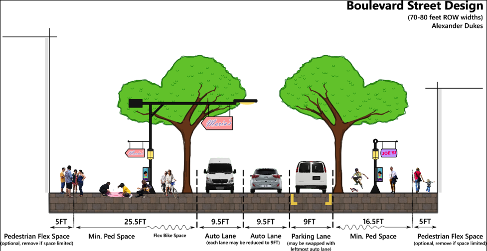


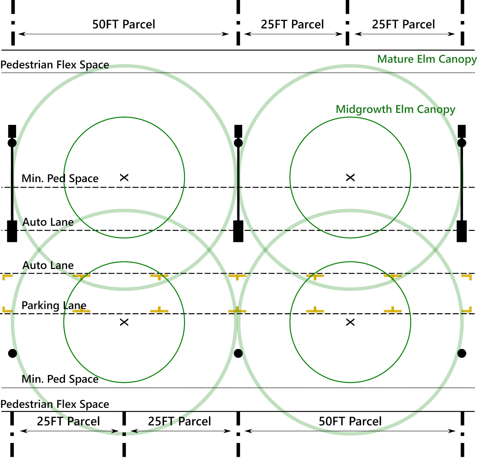
The first thing about this boulevard design most people will notice is that its pedestrian space feels exceptionally wide. This is due to the fact that most municipalities make the choice to prioritize auto traffic over pedestrian activity, and we have become culturally trained to dedicate most of the right of way to cars.
Auburn’s College Street, for instance, has a right of way width of 100 feet. In the past, pedestrians, horse-drawn wagons, and even cars (for a time) all shared the street simultaneously and spontaneously. Effectively, the 100 feet of College Street 100 years ago was likely either shared space or the pedestrian sidewalk. Today, the automobile roadway consumes 60 percent of College Street’s right of way with two driving lanes, two lanes of angled parking, and a left turn lane.
The boulevard street design for the mall site manages to commit 65 percent of its width to pedestrian space with less actual right of way to work with than College Street. This is done by doing away with turn lanes altogether, and having only one lane of parallel parking. With these auto-oriented features removed, much more space can be granted to the pedestrian.
Bike space also does its part to provide more pedestrian space. To accommodate cyclists on the boulevard, street trees and lamp posts/kiosks are spaced in such a way that they create a perceptive zone between them that should be relatively free of pedestrians. Cyclists, skateboarders, and Segways should largely hold to riding in this lane in-between the lamp posts and trees (as shown on the top image). The benefit of this bike lane’s informality is that it enables the entire pedestrian space to flex according to its immediate needs.
For example: A popular farm-stand vendor in the right of way might cause people to crowd slightly and spill into the informal bike lane. No big deal. For that specific moment, a cyclist might have to dismount their bike and walk through the crowd, or ride briefly with auto traffic. If the boulevard design used formal sidewalks and bike lanes and divided the two with a six-inch curb, the bike lane would be unable to flex with the immediate needs of the moment, and a valuable pedestrian experience would be harmed.
The sum result of all of this is that the remaining boulevard street space provides an enormous amount of room for pedestrians. The maximum 80 feet right of way is so vast that a shop can have a nine-foot expansion into the pavement on one side of the street, while another shop can have a four-foot expansion on the opposite side. In total, these expansions would take up 13 feet of space from pedestrians, and people would still have 39 feet of space to walk within. Additionally, the majority of street accessories (streetlights, public phones/info kiosks, trashcans, fire hydrants, etc.) would typically be located at lot lines to keep right of way free for lot expansion into the street. (Expansions from parcels into the right of way will be discussed in detail in a later article in this series.)
Finally, all of this pedestrian space would be sheltered by a sixty foot high vaulted canopy produced by fully mature Princeton Elms. The elms will gradually shade the entire streetscape as they grow taller and broader over the decades. Their purpose is not merely to appear beautiful (though they are), but also to shield pedestrians from the oppressive Alabama heat. Providing shade for pedestrians makes walking more comfortable, and therefore more common, and therefore improves community street life.
The Front Street
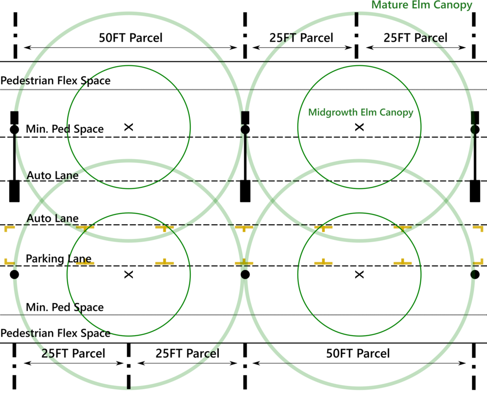

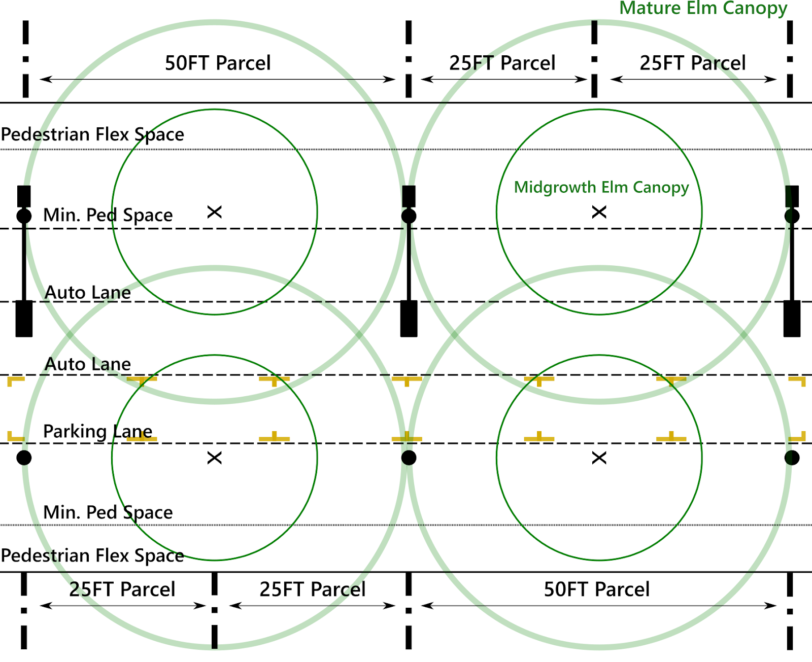
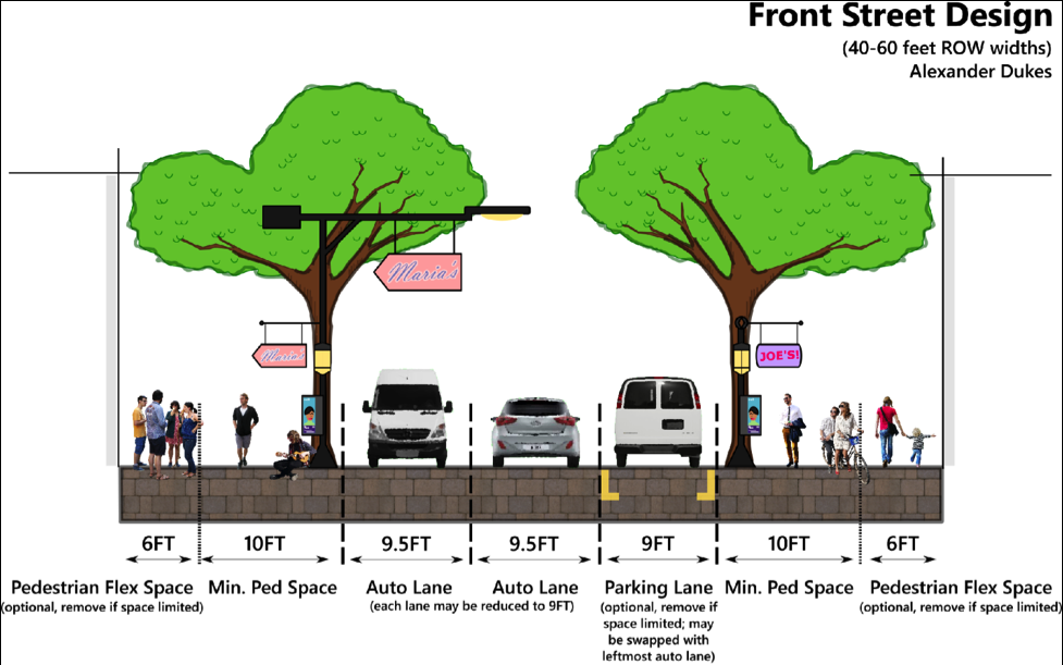
The front streets largely follow the same design paradigm established by the boulevard, except that the informal bike lane has been removed. Instead, street lamps and street trees are placed along the same line. This choice preserves a decent amount of space for pedestrians, but cyclists on these streets will either have to slow down within the pedestrian space or ride cooperatively with automobiles.
Front streets are intended to be calmer, bearing greater resemblance to a residential lane than a bustling boulevard. If you have a ground level residence on a front street, your porch or stoop should open to a space pleasant enough to serve as a kind of front yard. Yet, just because the front streets are calm and domestic does not mean they are inactive. Less noisy street activities like painting classes, flower kiosks, and outdoor dining may occur on them. (Precisely what land uses can occur on which streets will be discussed in a later article in this series.)
The Alley Street
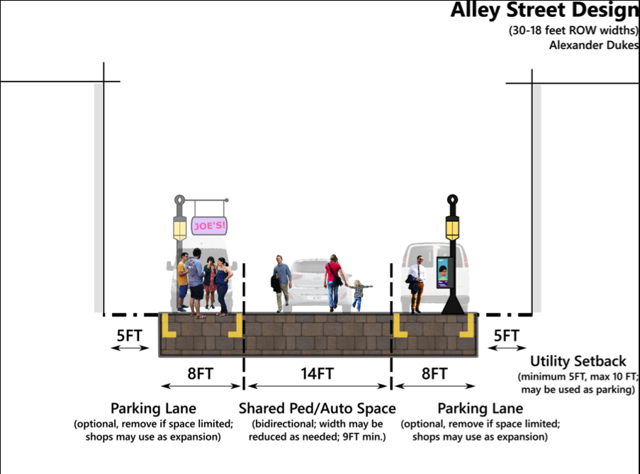


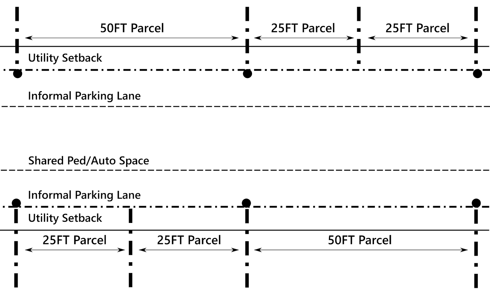
Rear alley streets are designed to be as flexible as possible. The first thing to understand about alleys is that while all buildings on boulevards and front streets must be built to the street, there is no such requirement for rear alleys. In fact, the foundation supported portion of buildings must be set back a minimum of five feet from an alley to keep utilitarian uses (trash cans, parking, electric meters, air conditioners, etc.) from cluttering up the alleyway. That being said, landowners can use the parking lane to expand out into the street with displays, stands, or structures that do not require a foundation- so long as their utility uses do not consume streetspace.
One problem readers may point out with this design is that in certain situations (like the one shown above) auto drivers might perceive the alleys as a wide open space to speed through. Please note that these street designs are only intended to show space allocations required for the street. Planners and civil engineers should add and remove certain elements according to circumstance. As long as the core concept of the design is retained, minor alterations are to be expected. In the case of the 30 foot alley shown above, a row of trees at every other lot line would likely improve the space. Also note that some alleys will be pedestrian only. (Those will be indicated in the final composite version of the full plan for the mall site at the end of the “A Town Well Planned” series.)
In closing, I would like to remind readers that neither Master Street Plans nor the Civic Development System they are a part of are intended to be dictatorial. Rather, these plans are meant to be developed in context and in consultation with the communities they affect. In the case of this article, before determining how the street will look in their town, civic planners should settle on an underlying theory to guide their street designs. In doing this, planners must ask a few questions: “What are our priorities within this limited right of way space? Are we prioritizing auto travelers over pedestrians? Do we really need a bike lane, or are wider sidewalks sufficiently safe? Should we have street trees?”
Such questions may seem simple at first glance, but they become frighteningly complex when you consider the context of specific streets, in specific neighborhoods, in specific municipalities. Each municipality and neighborhood is going to have different ideas about how to use their street space. Therefore, it is important that planners not only ask the aforementioned questions of themselves, but also pose these questions to the neighborhoods affected by the streets in question. In other words, planners need to determine what the “public will” for a street is. Take a look at my previous article, "Determining Public Will" for more ideas.
A Town Well Planned: Hierarchical Zoning

A mix of uses on Main Street in Ashland, Ohio. (Source: LI1324)
The first article in my “A Town Well Planned” series proposed a three-part regulatory system for managing the design of urban environments. The series refers to this system as the “Civic Development System,” or “CDS” for short. The three pillars of this regulatory system are: (1) The Master Street Plan, (2) Basic Land Use Zoning Plans, and (3) Form Plans. This article is the first of two that will describe the Zoning Plans pillar of the Civic Development System.
The concept of land use zoning is intended to prevent the various land uses from interfering with one another. There are three factors that determine whether a particular use of land is going to be harmonious and inoffensive to the public’s sensibilities: (1) The land use type, (2) the intensity of that land use, and (3) the geographic context of that land use. This article will focus on land use types and intensity. Next month’s article will geographically apply the factors of land use type and intensity to the Auburn Mall site.
Land Use Types
There are four principal types of land use: Residential, Office, Merchant, and Industrial/Utility. Residential land uses are primarily dedicated to homes and the domestic life of the public. Office land uses are leveraged for the production of services that are of a highly skilled or clerical nature. Merchant land uses are reserved for the selling and purchase of goods and services. Industrial and Utility land uses are those that require the generation of nuisances like smoke, noise, or excessive traffic.
The defining characteristic of land use types is their flexibility. Districts that are zoned residential are the least flexible because they cater to those that desire an environment designed for domestic (and in most of the United States, a semi-bucolic) life. Industrial land uses are the most flexible because people are generally unconcerned with the activities that occur in industrial areas as long as they're not interfering with the rest of the city or harming the environment. Because residential districts are so inflexible, industrial land uses should not be placed within them. The noise, shipping traffic, and odor of many industries will harm homeowners’ enjoyment of their residential land. The residential land district is therefore harmed by the presence of industrial land uses.
However, this is not true of the inverse. If a person chooses to build a house within a light industrial zoning district, there is no harm the home can do to the adjacent industrial land uses. In fact, both the resident and the employer gain from this arrangement: The employee gains a shorter commute to work, and the employer gains a better-rested and productive worker.
Unfortunately, contemporary single-use zoning (aka “Euclidean” zoning) does not allow residential land uses within industrial zoning districts. This is due to its strict segregation of each land use type. This article will demonstrate how a hierarchical zoning paradigm can address this critical failure.
To allow less flexible land uses within districts zoned for more flexible uses, zoning codes should develop a flexibility hierarchy. Such a hierarchical model is displayed below, using the aforementioned four types of land uses:
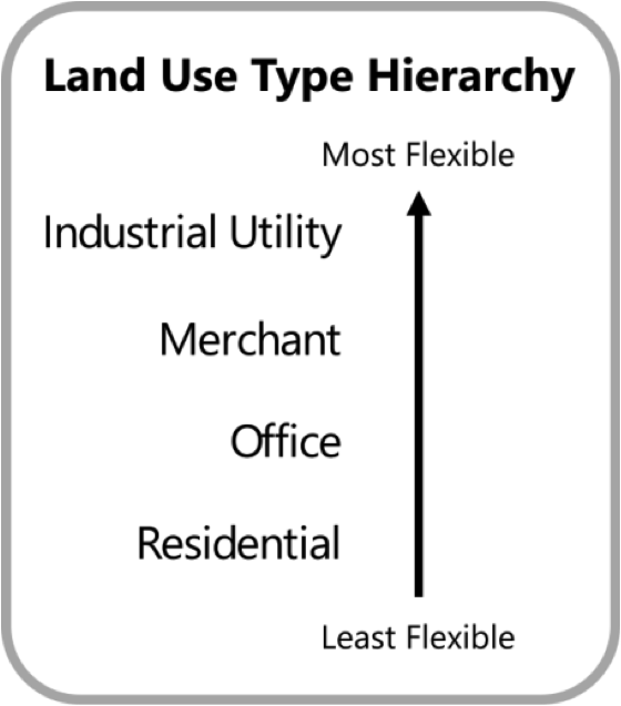
As the model’s arrow implies, any less flexible land use can exist within the more flexible districts above it. For instance, office land uses can occur in districts zoned office, merchant, or industrial. Office land uses may not occur in areas that are zoned residential, because residential land uses are less flexible than office land uses.
This hierarchical zoning paradigm also allows for the easy mixing of uses. If the owner of a small blacksmith shop wants to build a house above their workshop, this zoning paradigm allows him or her to do so. Using a system based on hierarchies affords the public more freedom to maximize the use of their land, which should be the aim of both landowners and the municipality.
Land Use Intensities
Land use intensities are related to the amount and type of activity a parcel hosts. Ensuring compatibility between land use intensities is just as important as ensuring compatibility between land use types. For example, most people don’t want to live in a cozy suburban house across the street from a supermarket. The persistent traffic and sterile aesthetics of the typical supermarket environment would harm the coziness of the residents’ house. Therefore, cities tend to put some distance between supermarkets and suburban homes. However, the residents of a six-story apartment complex might appreciate being across the street from supermarkets. The intensity of the supermarket’s land use is more compatible with the intensity of the apartment complex.
As it was with land use types, more intense land uses should accommodate less intense land uses by right. A model of an intensity hierarchy is displayed below. For the purposes of the Auburn Mall (our case study for this series of articles), four levels of intensity will be used. Additional levels of intensity can and should be added for larger cities.
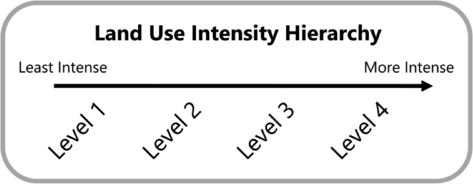
With this hierarchical model of land use intensity, the four land use types can be given their own measure of intensity. For residential and office land use types, land use intensity levels are inherently tied to the number of people using a space. Intensity levels for mercantile land uses are tied to the “gross commercial floor area” associated with the structure(s) on the lot. For light industrial land uses, intensity levels are mainly related to the amount of noise, noxious exhaust, and public safety hazards generated on a particular industrial site.
To determine what constitutes a “level,” some delineation of each land use type’s intensity levels must be prepared. Delineations for the different intensities of land use types are shown in the chart below.
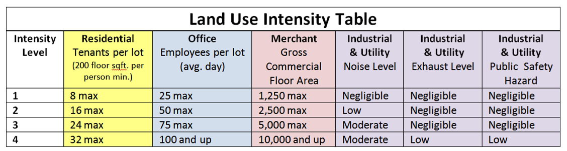
All structures remain subject to the city’s fire code. Individual residential structures used to house 6 or more persons on a single floor are subject to city safety review. An “industrial & utility” land use shall be classified as the highest intensity that meets any one of its relevant measures.
For reference regarding commercial floor area footage sizes, the average McDonalds is 4000 square feet, while the average Five Guys and Chipotle are between 2,000 and 3,000 square feet. [Source: Auction.com]
The land use intensity and type models and table provide developers a means to determine whether the specific land use they seek to apply to a parcel is allowed. However, it may be conceptually difficult to apply the land use type and land use intensity factors concurrently. Developers would have to flip between pages of the zoning code to determine exactly where their proposed development fits. To remedy this, there should be a land use zoning matrix to simplify zoning code lookups to a single page. Enter the zoning matrix.
The Zoning Matrix
By using land use type hierarchy as a y-axis and land use intensity hierarchy as an x axis, a two dimensional zoning matrix can be formed. The matrix allows a municipality to visually illustrate the concept of the land use hierarchies in a way that can be easily understood by both the general public and seasoned developers.

Developers would use the matrix to determine where they are allowed to build their proposed developments. This would occur in a two-step process: First, developers would use the land use intensity table to determine the type and intensity of their proposed development. Next, the developer would use the matrix to determine which zoning districts can accommodate their development. Four examples below demonstrate this process.

In Example 1, a developer seeks to construct an “R1,” or “Residential – Level 1” land use—for example, a small single-family home. The R1 land use can be within any land use district. Effectively, the developer has no restrictions with respect to where they can construct an R1 class home.
However, Example 2 indicates that a developer is seeking to construct an “IU4,” or “Industrial Utility – Level 4” land use like a large factory. Unfortunately, a level 4 industrial land use can only be built in the IU4 district. Industrial land uses of this intensity must be isolated to unique industrial zones to protect property values and public safety.
Example 3 presents an interesting situation where a developer seeks to build an “M2” land use such as a midsize clothing store. Being in the middle of the land use matrix, the developer has some ability to “move” to other zoning districts, but not the freedom to select any zone they desire. This illustrates how developers can only move upward and rightward from their development’s zone within the matrix. Moving to the left or downward is prohibited because those movements would violate the concept of the land use hierarchies.
Example 4 demonstrates how the land use hierarchies interact with one another. Because the “R4” land use—for example, a large condo building—is the ultimate residential land use, the developer cannot move down the intensity hierarchy within the matrix. But, the developer can move up the type hierarchy, to build an R4 land use in an O4, M4, or IU4 zoning district.
Conclusion
The hierarchical zoning codes’ ability to expand the public’s liberty to build what they want, where they want will improve the health of the land market in municipalities. The ability to combine residential land uses with office, work, or mercantile uses will inevitably drive down the cost of housing and allow entrepreneurs to mitigate their risks with live-work arrangements.
With a more flexible zoning code that recognizes the hierarchies inherent in land use types and intensities, cities can overcome many of the problems inherent in single-use zoning. Developers should only be constrained in their ability to develop land uses when their choice of land use harms others in the zoning district. By adopting a hierarchical zoning code, we can cast off many of the single-use zoning proclivities that have held our municipalities back.
Next month’s article in this series will geographically apply this hierarchical zoning code to the Auburn Mall site.
A Town Well Planned: Zoning with Context
The concept of land use zoning is intended to prevent the various land uses from interfering with one another. There are three factors that determine whether a particular use of land is going to be harmonious and inoffensive to the public’s sensibilities: (1) The land use type, (2) the intensity of that land use, and (3) its geographic context. This article will focus on understanding the geographic context of the hierarchical land use regulations discussed in the previous article. To see how these regulations can be used in practice, a hierarchical zoning scheme will be applied to the Auburn Mall site, which I have previously platted and prepared street designs for.
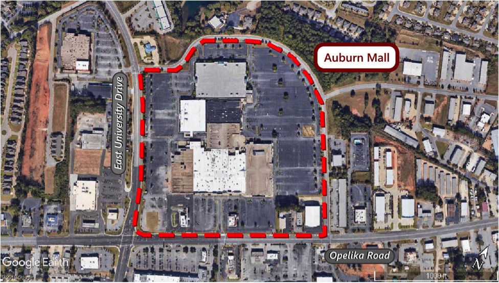
A theoretical basis to govern the application of a zoning code to the land is required to effectively regulate land use in a municipality. Contemporary zoning theories are often intended (consciously or not) to support our national system of development financing, where tracts of coarse-grained land uses are “bundled” by banks into generic loans. Shares of these loans are then sold to blind investors all over the country who have no connection to the land they own.
To pitch these generic loans to blind investors, the local zoning system must be blunt and lack geographic context. In part, this is why municipalities have largely given up master street planning and only zone commercial land on arterial roads. Developers are then allowed to design whatever residential space they want to feed those arterials. This becomes a self-perpetuating cycle, where perpetually increasing amounts of residential land are required to feed the arterial’s commercial appetite.
At Strong Towns, we believe in the traditional development pattern where blocks and parcels are financed locally. A traditional pattern of development requires zoning that is fine-grained and geographically contextual to civic amenities and land features. To achieve that, we need a theoretical basis for zoning that is responsive to observable feedback.
Municipal and Neighborhood Transects
An urban transect is a conceptual means of understanding the built environment in a town or city. Urban transect theory posits that urban development intensity will broadly rise as you move from the outskirts of a town into its downtown core. If one were to graph a municipality’s level of built intensity from its downtown core to its hinterlands, the line would broadly start at a peak (the downtown) and bend down toward zero (the hinterland). This is how transect theory is generally understood.
Though it is a good basis from which to start, I find even this theory too simplistic because it ignores the hyper-locality of urban neighborhoods. Most cities don’t follow a linear declination from their center out to hinterland. In-between the peak and the zero, there should be many smaller hills and valleys to account for natural intensity fluctuations that occur where land is particularly valuable. Where these hills and valleys occur on the graph would also depend greatly on which streets you were measuring.
This reality of an inconsistent transect gradient requires a conceptual separation of the larger municipal transect from the smaller neighborhood transects. This conceptual separation is illustrated below for the Auburn Mall site’s relationship to the City of Auburn:

In the diagram above, the graph follows a common route people take from downtown Auburn to the Auburn Mall. There are four significant intersections along this path, and the mall lies on the busiest single intersection of the four (collectively, downtown Auburn is busier). This intersection is where Opelika Road crosses University Drive. Each of these intersections can be considered the physical manifestation of a neighborhood transect peak, and a potential “town center” for a neighborhood.
Until recently, the city ignored these signals and applied coarse zoning based on arterial routes. This zoning paradigm completely separated residential areas from commercial areas. The Auburn Mall is a perfect example of this separation: People only enter the mall to shop, and typically get there by driving on one of two arterial routes. The fact that the mall is only used for shopping reinforces this status quo daily.
Let’s see what we can do when we take the land the mall consumes and zone it to be a place where people can live, work, shop, and play. My objective with this zoning code application is to transform the Auburn Mall site into a cohesive community that serves as a town center for its neighborhood.
Zoning the Auburn Mall Site
In applying the hierarchical zoning code to the Auburn Mall site, I have tried to give land owners the greatest amount of freedom possible while still providing the neighborhood with some intentionality. While the master street plan that forms the streets and blocks is fairly prescriptive, I think the zoning code and its application to the land can be considered a significant expansion of individual rights compared to other zoning systems.
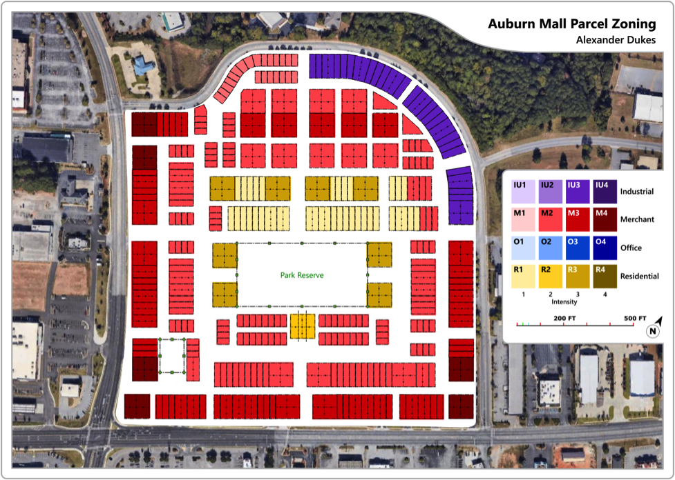
University Drive is the north-south road on the western side of the site. Opelika Road is the east-west road on the southern side of the site.
Let’s begin at the arterial intersection that makes all of this possible. Opelika Road and University Drive are attractive to commercial developers because they handle a great deal of traffic. If this community were developed as platted, merchants would compete furiously along the arterials to peel hurried pedestrians off the sidewalks and errand-running drivers from the roadways. Multistory mixed use buildings with homes above offices and restaurants would thrive here. Therefore, I gave land along the main thoroughfares the highest intensity zoning the community has to offer.
Zoning intensity decreases beyond the first ring of parcels. Mercantile and office land uses will consume less space than those on the exterior, while fewer people would be on the street hustling to their next appointment or running errands. This space is intended for people to linger and enjoy the pleasantness of each-other’s company. I use this intensity declination to transition the community from its public face (the exterior on Opelika Road and University) to its more private heart.

Source: USAG - Humphreys
In the center of the community, you reach the heart. Here, children could play soccer in the park while their parents observe from their porches and balconies. Land zoned to be exclusively residential bounds every end of the park except its southern edge. Because the park is the “heart” of the community, I felt it needed to have a good number of single family homes and apartments to buttress it against the interior boulevard lined with retail and office land uses.
The northeastern, curved edge of the Mall site is zoned to accommodate industrial land uses. Because the industrial block of the community faces an undeveloped crop of trees, relatively few parcels will be harmed by the nuisances generated by industries. Perhaps local shops, manufacturers, and homeowners could use this land to form a communal live-work space for small business owners, artists, and professionals.
Working in concert with the master street plan’s arrangement of the land, the hierarchical zoning code can be used to design a neighborhood town center where people live, work, shop, and play. The Auburn Mall case study demonstrates that all of these various land uses and activities can be comfortably compressed within a place that is just a little more than a quarter mile wide. Imagine what we would see if the whole city embraced master street planning to arrange the land, and hierarchical zoning based on transects to define land use.
Conclusion and Discussion
Please remember, this zoning code is hierarchical. Any land use that is less intense or less sensitive than what a given parcel is zoned for can occur on that parcel. For example: although most land in the Mall site is zoned to accommodate merchant land uses, office and residential land uses that are at or below a merchant parcel’s zoned intensity can occur on that parcel. Additionally, multiple land uses can be combined on one parcel. (Please read the previous article in the series for more information on how this hierarchical zoning system works.)
“The traditional pattern of development requires that our neighborhoods be built incrementally, step by step, with local financing. It is through that process that we achieve the beautiful mosaics of buildings and fine-grained land uses that define the great cities of the world.”
The beauty of this hierarchical zoning system is that it permits this under-utilization of zoned land without issue. This frees the planner and residents from having to guess at what specific land uses should be in allowed in a place, and instead focuses their attention on the cohesive whole a place can be. In a properly applied hierarchical zoning code, the market is given the headroom to decide what level of development is appropriate for each parcel.
When the Mall site initially starts redeveloping, most buildings on its edges will only rise to one story. This is well below the potential the land is zoned for. Some structures may even be single family homes. That’s okay too. The traditional pattern of development requires that our neighborhoods be built incrementally, step by step, with local financing. It is through that process that we achieve the beautiful mosaics of buildings and fine-grained land uses that define the great cities of the world.
Even with the master street plan and zoning plans complete, there are still a few problems that need to be addressed on the Mall site. Which way should buildings face? How does the city ensure consistent setback distances to prevent recesses and dead-end alleys along streets? Can developers build infinitely high, or will there be height limits? Are landowners allowed to build across parcels?
These are questions that need answers. Solutions to them will be discussed in the final quarter of this series. Over the next two months, we will discuss form codes and plans for the Auburn Mall site.
A Town Well Planned: Universal Form Codes
Form codes and plans are relatively new regulatory tools in the civic planning toolbox intended to better control the design of developed land. In regulating the form of land, planners primarily seek to control building heights, footprints, frontage, and setbacks. Note that form codes and form plans are not the same thing. A form code defines the terms by which the design of land will be regulated, such as: “the city’s building height limits will be divided into three 30, 50, and 70 foot increments.” A form plan applies that form code to specific blocks or parcels, such as: “the city will apply 30 foot height limits along Oak Street, and 50 foot height limits along Spring Street.”
In this article, a foundational form code and form plan will be developed for this series’ case study: the Auburn Mall site. These codes and plans will be universally applicable to all parcels in the site. In the next article, we’ll dig a little deeper into form plans and use some geographic context to apply more specific regulations on individual parcels.
As a refresher, let’s take a look at the types of lots that are available to developers in the Auburn Mall site as it’s been platted and zoned:

As shown, the majority of parcels have dimensions of 25 x 50 feet, 25 x 100 feet, or 50 x 100 feet. This means that space on most parcels is at a premium. Any form code that regulates land use on parcels this small must balance reasonable safety and appearance regulations against landowners’ desires to maximize the use of their land.
The General Form Code and Parcel Plans
On the mall site, all parcels will be governed by the form code described below:
Auburn Mall Site Form Code (Part 1)
Lot Front – Defined by the city, this lot edge requires built structures to present the public face of the parcel. Generally, the front of a lot is the side that meets the street/sidewalk. Within illustrations, the front of a lot is indicated with a black arrow.
Port and Starboard – Refer to the left (port) and right (starboard) sides of a parcel, as oriented from the front of the parcel. In the maritime context, the “port” side of a vessel is the left side of the ship when looking to the front of the vessel. The “starboard” side is the right side when looking to the front.
Primary Structures – Structures that have 3 or more of the following 4 characteristics: (1) Being essentially enclosed with impermeable walls, (2) climate controlled with active cooling/heating of air, (3) serviced by water/sewer utilities, and (4) only accessible through lockable exterior entryways. Primary structures are typically homes, offices and other buildings that people occupy.
Porches and Other Auxiliary Structures – Generally, structures that have 2 or less of the following 4 characteristics: (1) Being essentially enclosed with impermeable walls, (2) climate controlled with active cooling/heating of air, (3) serviced by water/sewer utilities, and (4) only accessible through lockable exterior entryways. Auxiliary structures tend to be garages, sheds, and other structures that aren't meant for human habitation.
Structural forms that constitute exceptions to the general rule will be maintained by the city.
Except for lots with industrial land uses, porches are the only auxiliary structures permitted on the front edge of a lot unless a particular auxiliary structure has been specifically permitted as an exception by the city.
Front and Rear Build-to Line, Build Areas – The area(s) or line(s) a primary or auxiliary (one or both of which will be indicated) structure must be within or abut. Exceptions will be made for garages and other auxiliary structures specifically described.
If no build-to line exists, the front lot line itself functions as the “build to” line for auxiliary or primary structures. If no build area exists, the entire parcel may be built upon — excluding setbacks, minimum build depths, and maximum build depths.
Setbacks – Setbacks define a distance from a given lot edge or other geographic feature within which construction is either restricted or not allowed at all. Ex: “We cannot build a home within the 5 foot setback from the port-side lot edge.”
Minimum Build Depth – The distance from a given lot edge or other geographic feature within which construction of a defined description must occur. Ex: “The minimum front porch depth from the lot’s front edge is 5 feet.”
Maximum Build Depth – The distance from a given lot edge or other geographic feature within which construction of a defined description may occur. Ex: “The maximum front porch depth from the lot’s front edge is 10 feet.”
Generally, parcels will be governed by applying the aforementioned form code to the parcel form plan illustrated below.
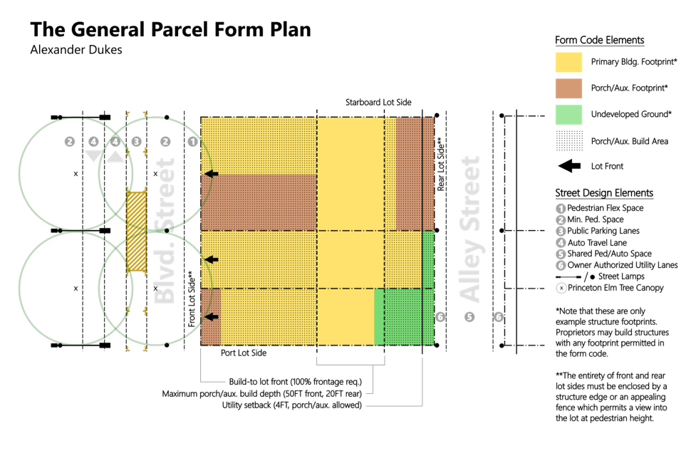
Regardless of the parcel’s size, the dimensions in the General Parcel Form Plan will be applied to almost every parcel in the development (except for parcels zoned R1, which we’ll get to momentarily). The structure footprints shown in yellow, green, and brown are examples of what developers can do within the regulations. I’ve also included the street designs developed in the series’ fourth article for context.
If one thinks back to the first article in this series, this illustration represents the mating of two of the three elements the A Town Well Planned series: Parcel/Street Plans and Form Codes. A developer would only need to look up the Zoning Plan to gain most of the regulatory information about their parcel. Splitting development regulations into three simple elements is vastly more streamlined compared to most municipalities’ planning processes.
These spatial allowances in the General Parcel Form Plan provide developers the maximum utilization of the limited square footage they are afforded. As shown, the optional “auxiliary setback zone” gives developers the option of adding porches and other outdoor seating areas on up to 50 feet of lot depth from the front. This is in addition to the 6 feet of “pedestrian flex space” allocated in the street design for public solicitation. (See Street Design article in this series for more information on pedestrian flex space and other street uses.) With the adaptability provided by these regulations, commercial land uses can optimize this combined 56 feet to create inviting outdoor dining areas or open air markets, offices can feature breezy porches where their employees relax or work in the fresh air, and avid gardeners can have greenhouses attached to their homes.
On the rear, parcels have another 20 feet of space provided for auxiliary structures that don’t belong on the street-facing front of the lot (such as sheds and garages), plus an additional 4 feet of public right of way on the rear alley dedicated to “owner authorized utility.” This utility space on the alley can be put to use in any non-structural way that the abutting property owners see fit — for instance, using it as a place to store trash cans. Finally, primary structures must be setback at least an additional 4 feet from the parcel’s rear edge. The 4 foot setback and the 4 foot utility lane exist to keep activities like trash pickup, parcel delivery, and car parking out of the alleyway’s “woonerf” style shared pedestrian/auto lane.
Detached Home Parcel Plans
The aforementioned general form dimensions will apply to all land uses except the “R1” residential zone for the lowest intensity residential neighborhoods. (See Hierarchical Zoning article for further explanation of these zones.) The R1 zone allows up to 8 people to live on a parcel with a minimum of 200 square feet per person. Generally, such parcels will be used to host single family homes and duplexes (though one could conceivably place 8 individual tiny homes or micro-apartments on a parcel). Because single family and duplex land uses tend to be more vulnerable to hazards like robbery and fire, parcels zoned “R1” will feature form dimensions that attempt to mitigate these risks. The dimensions for parcels zoned R1 are illustrated below.
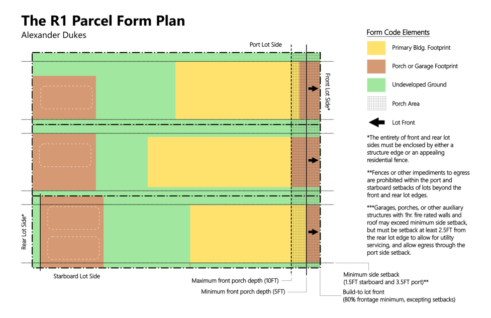
In the R1 Form Plan we can immediately see that the side setbacks and shorter front porch allowance are the main differences between the R1 Parcel Plan and the General Parcel Plan. Additionally, there is no mention of a rear porch or auxiliary space on this plan, which means the amount of rear auxiliary space is left to the discretion of the lot owner. Finally, there is also a front porch minimum depth, which means a front porch is required for R1 land uses.
The “minimum side setback” is 1.5 feet wide on the starboard sides of parcels and 3.5 feet wide on the port sides. The reason for these setbacks is to force structures on each lot to have a minimum of 5 feet of distance between structures while still providing sufficient room for someone to walk along the port side. The purpose of forcing 5 feet of distance between each structure is related to the International Building Code, which stipulates that buildings with less than 5 feet of distance between them and the nearest lot line must have a fire wall rated to last one hour. This design fudges this a bit, and enforces a five foot separation between each building. If the fire chief has a problem with it, the homes will just have to be built out of brick.
Porches of at least five feet in depth are required at the front of the lot, with a maximum of ten feet of porch depth allowed. The purpose of requiring porches on these lots is to discourage unauthorized trespass or peering onto the lot. These porches are intended to act as southern incarnations of the “stoops” featured on brownstones that are popular in northeastern cities like Brooklyn and Philadelphia. Adding a few steps to elevate the doors and windows of the living space above the street contributes to the privacy of the residence while still maintaining that safety that comes from “eyes on the street.” Such measures are employed to provide residents with a sense of security and “defensible space” in a relatively dense environment.
Little Big House
Now, many people who are used to large suburban lots may consider a 25 x 100 foot lot far too small to build a reasonable house upon. While this may have been true in comparison to homes built in the early 20th century — when sturdier building materials like steel and glulam were rarely used in single family residential construction — homes on small lots today can be far roomier and open than those built a century ago. To demonstrate this point, I have designed a three bedroom, three bathroom home that can fit on the smallest lot in the mall site design: 25 x 50 feet.
Please note: I’m not an architect. Though I did as much research as I possibly could on common regulations governing the dimensions required within residential plans, it is likely that I missed something. Nevertheless, I am relatively confident that the necessary changes would be minor and that the basic layout of the house is acceptable. Below is a plan view of a two-story, three bed, three bath home on a 25 x 50 foot lot.
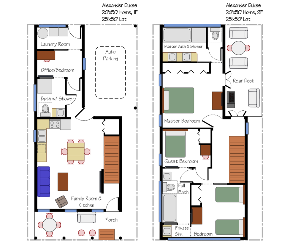
This home design is the intellectual property of Alexander Dukes. It is used here with permission.
Is the home a bit snug and cozy? Yes. On a 25 x 50 lot, a home designed to sleep four to six people is going to have compressed living quarters compared to a suburban estate. On the other hand, consider the amount of money a decent-sized family can save by building this house on such a small piece of land. If the first floor office and guest bedroom are leveraged as kids’ bedrooms, a family of six can live in this house relatively comfortably. Alternatively, a family of four can invite an aging grandparent to live in the home with them. I even left space for a car to park!
Keep in mind, this is the smallest lot in the whole mall site design. Residents on more common 25 x 100 lots can construct homes larger than this and still have room for a small backyard and two car garage (as shown on the R1 Parcel Form Plan).
Finally, the following sketch demonstrates how this single family residence would appear on the street with all of the R1 regulations applied.
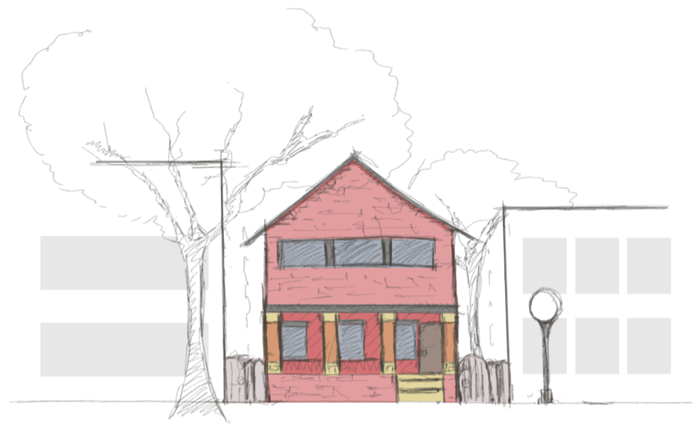
I think that’s a perfectly reasonable southern home within a tight-knit downtown community. And by applying both the general form dimensions and the special R1 dimensions to the whole mall site plan, we end up with a vision for a beautiful southern community in Auburn.
The next and final article for this ‘season’ of the series will demonstrate additional form plan elements that need to be applied with geographic context to the site and show how everything we’ve discussed thus far will come together to establish a framework for a successful, intimate urban environment.